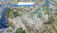
After a long stretch of warm fall weather the storm gate opens up this weekend.
A cold front will move through the region late Friday into Saturday bringing much cooler air, chances for rain and snow, as well as wind along with it. Fire danger will be a concern for several hours before the front arrives and relative humidity levels rise.
There will be a break in activity by late Sunday and Monday but it will be chilly, especially in the morning. A Freeze Watch has been posted for western Nevada beginning Saturday evening and going through Sunday morning. A
Fire Weather Watch has also been posted for the Truckee Meadows beginning Friday night and going through 8am Saturday.
Once this storm moves through it will make it easier for other storms to follow suit. There is a lot of disagreement between models what happens next week after Tuesday. One model showing another storm rolling through, and another model drying us out.

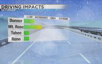
Impacts from this weekend’s storm will be light to moderate depending on elevation.
The snow level will crash to 5000’ Sunday morning, but by then the majority of the moisture will be south of I-80. Snow totals will range from less than an inch at Donner to a few inches along Mt. Rose Highway above 8000’.
While there will be snow falling at lake level, accumulations will be minimal.
Only expecting light rain in the Reno area Saturday beginning in the late morning and going through the evening. There is a good chance for rain in the valley, but it won’t be heavy. Rain totals will range from a trace to a tenth of inch.
The ground is still quite warm, so snow will take a little while to stick in the higher elevations, first accumulating on grassy areas before sticking to the roadways. Most of Sunday will be dry, but chilly.

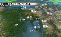
There is also a chance for Lake Effect snow Sunday morning for areas downwind of Pyramid and Lake Tahoe. Lake waters are still warm compared to the air mass coming through, allowing the air to rise as our winds switch out of the northwest.
Lake effect is hard to predict, but it’s possible places like Fernley could see a couple inches of snow Sunday morning.

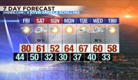
It’s going to be cold this weekend with temperatures dropping twenty degrees from Friday. Highs on Friday will near 80 degrees and they’ll only be in the 50s and lower 60s on Saturday. It will even be ten degrees cooler on Sunday, putting us in the lower 50s.
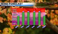
Now is the time to get all of your last veggies picked and winterize your sprinkler systems before temperatures fall below freezing area wide. The wind will make it feel cooler too. They will be gusting in the 30s and 40s Friday night before easing on Sunday.
The high Sierra will see wind gusts over 60mph as the front moves through Friday night. This is not a huge storm, but is a sign that our weather pattern is changing.
Follow me on Facebook at KTVN Angela Schilling for more weather updates. You can also follow me on Twitter and Instagram at Angela Schilling.