...FLOOD WATCH IN EFFECT FROM TUESDAY AFTERNOON THROUGH TUESDAY
EVENING...
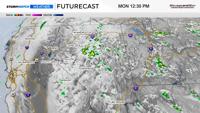
* WHAT...Flash flooding caused by excessive rainfall is possible due
to thunderstorms.
* WHERE...Portions of east central California, including the
following area, Greater Lake Tahoe Area and western Nevada,
including the following areas, Greater Lake Tahoe Area and Greater
Reno-Carson City-Minden Area.
* WHEN...From Tuesday afternoon through Tuesday evening.
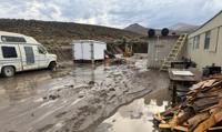
* IMPACTS...Excessive runoff may result in flooding of creeks,
streams, urban areas, burn scars, and areas near steep terrain.
* ADDITIONAL DETAILS...
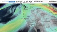
- Deeper monsoonal moisture combined with daytime heating will
produce scattered thunderstorms Tuesday afternoon and
evening. Slower moving storms could redevelop over similar
areas, increasing the risk for heavy rainfall capable of
producing flash flooding.
- http://www.weather.gov/safety/flood
PRECAUTIONARY/PREPAREDNESS ACTIONS...
You should monitor later forecasts and be prepared to take action
should Flash Flood Warnings be issued.
&&