



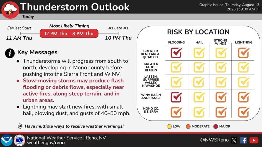
A dangerous round of thunderstorms is moving across western Nevada Thursday afternoon, with a tornado warning in effect for parts of Storey, Washoe, and Lyon counties as forecasters also warned of large hail, strong winds, and flash flooding.
The National Weather Service in Reno said at 1:37 p.m. that a severe thunderstorm capable of producing a tornado was near Derby Dam, about 16 miles northeast of Virginia City, and moving east at 15 mph. Radar indicated rotation, and the tornado warning was scheduled to remain in effect until 2:15 p.m. for Storey County, Southern Washoe County and North-central Lyon County.
The storm is expected to remain near Derby Dam around 1:40 p.m. and reach Fernley around 1:55 p.m. Wadsworth and Fernley-Tiger Field Airport were also among the locations identified as being affected by the storm.
The latest tornado warning listed tornadoes and quarter-size hail as the primary hazards. The National Weather Service said radar indicated the storm could produce hail up to 1 inch in diameter.
The warning also carried the potential for dangerous flying debris, damage to mobile homes, roofs, windows and vehicles, and tree damage. The National Weather Service urged people in the warning area to move immediately to an interior room on the lowest floor of a sturdy building and stay away from windows. People outdoors, in mobile homes or in vehicles were advised to move to the closest substantial shelter and protect themselves from flying debris.
The tornado threat came as another severe thunderstorm warning was in effect for the same general area. At 1:32 p.m., the National Weather Service said a severe thunderstorm was near Derby Dam, about 16 miles east of Reno, moving northeast at 5 mph.
That storm is capable of producing golf ball-size hail and wind gusts up to 60 mph. The National Weather Service said those conditions could injure people and animals outdoors and damage roofs, siding, windows, vehicles, fencing and trees.
The severe thunderstorm warning was scheduled to remain in effect until 2 p.m. for Storey County, South central Washoe County and Northern Lyon County.
At the same time, heavy rain was creating a separate flash flooding threat around Reno and nearby communities.
The National Weather Service issued a flash flood warning for Storey County and South-central Washoe County until 4:15 p.m. Radar indicated thunderstorms were producing heavy rain, with between 0.8 and 1.5 inches already recorded in the warned area. The weather service said flash flooding was ongoing or expected to begin shortly.
The flash flood warning included Reno, Sparks, Lockwood, Hidden Valley, Reno-Tahoe International Airport, Mustang and Patrick. Potential impacts included flooding of small creeks and streams, urban areas, highways, streets, underpasses, low-lying areas and places with poor drainage.
A separate flood advisory for Storey and southern Washoe counties, including the greater Reno area, was scheduled to remain in effect until 3:45 p.m. The advisory was issued because of excessive rainfall, with minor flooding possible in low-lying and poorly drained areas.
Reno, Sparks, Reno-Tahoe International Airport, Hidden Valley, Damonte Ranch, Caughlin Ranch, northwest Reno, the National Weather Service office and Sun Valley were among the locations identified as potentially affected.
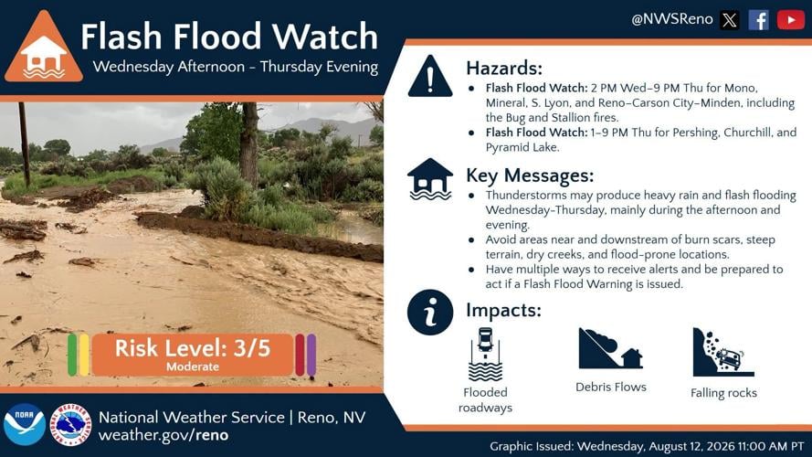
The weather service also continued a broader flood watch through Thursday evening for the greater Reno-Carson City-Minden area, including Gardnerville, Verdi, Sparks and Virginia City. The watch specifically included the Bug and Stallion fires.
The concern around the active fires is not simply additional rainfall. The weather service said excessive runoff could produce rock, mud and debris flows in and near active fire perimeters, steep terrain and poorly drained urban areas.
The broader flood watch was also expanded to include Pershing and Churchill counties and the Pyramid Lake area from 1 to 9 p.m. Thursday. Earlier portions of the watch included Mono, Mineral and southern Lyon counties and the greater Reno-Carson City-Minden area.
The National Weather Service said thunderstorms were expected to continue producing heavy rain and flash flooding concerns during the afternoon and evening, with recent burn areas and steep terrain among the locations of particular concern.
Beyond the tornado warning, the weather service was tracking a strong thunderstorm at 12:50 p.m. about 15 miles east of Yerington, or 33 miles south of Fallon, moving northeast at 55 mph. That storm was capable of producing wind gusts up to 50 mph and hail around one-half inch in diameter.
The storm threat extended across a broad portion of the eastern Sierra, the Sierra Front and western Nevada. Locations identified as potentially affected included Reno, Carson City, South Lake Tahoe, Fallon, Mammoth Lakes, Lovelock, Gardnerville, Virginia City, Pyramid Lake, Incline Village and Bridgeport, among others.
The weather service warned that gusty winds could knock down tree limbs and blow around unsecured objects, while hail could cause minor damage to vegetation.
For people encountering flooded roads, the National Weather Service warned against attempting to drive through the water. The agency emphasized that most flood deaths occur in vehicles.
With thunderstorms capable of producing tornadoes, large hail, strong winds and heavy rain moving through the region, multiple weather hazards were unfolding at the same time Thursday afternoon.