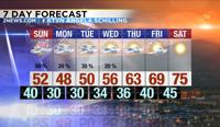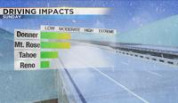
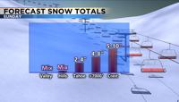
It might be the beginning of May but winter still does not want to leave for the season. A Winter Weather Advisory has been posted for the Sierra, including Tahoe on Sunday going from 11am through 11pm. Expect some delays along our mountain passes on Mother’s Day and through at least Monday. The snow won’t be widespread, but showery and scattered in nature. Very similar to thunderstorms. Meaning some people could see lots of snow and others not very much. It will be warm enough for rain in the valley during the day, but some snow could mix in by the early nighttime hours. Highs on Sunday will range from the 20’s in the high Sierra, to the low 50’s in the valley. Roads will be slick enough in the Sierra to cause some delays, and possibly chain controls. The wind will also blow around the snow, lowering visibility. Roads in the valley will stay wet. Wind gusts will reach 50mph in the valley and wind prone areas could see wind gusts over 60mph.


A large area of low pressure has already moved over the Pacific Northwest through northern Nevada this weekend, but a colder part of the low will move in on Sunday. This cold front will drop temperatures another fifteen degrees from Saturday afternoon. Highs will be twenty degrees below normal on Mother’s Day and feel more like the 40’s because of the wind. The cold air will be sliding in from the Gulf of Alaska and sticking with us through at least Wednesday. The cold area of low pressure aloft will also make the air more unstable and conducive for showers. Warm air rises, so when there is cold air above warmer air, the air has an easy time rising. The set up on Sunday is similar to thunderstorms, meaning not everyone will get wet, and rain/snow totals will vary greatly. Snowfall rates could reach 1-2 inches per hour in heavier snow bands. Reno will see mainly rain on Sunday, but some snow could mix in late Sunday evening. No accumulations are expected in Reno. However, road conditions in the Sierra will switch from slick and covered in snow, to wet with melted snow the next. It all depends on the strength of the individual snow band. Snow totals will range from nothing in the valley, to a few inches at lake level, and several inches in the high Sierra above 7000 feet.

As the low travels south on Monday, a few more showers are possible both in the valley and the Sierra. The low won’t be fully out of here until late Wednesday. There is a slight chance for rain in the valley Tuesday and Wednesday, with snow possible in the mountains. The brunt of the storm will be late Sunday. Lows will fall below freezing Monday and Tuesday, so make sure to protect your plants, pipes, and sprinkler systems, even in the valley. Reno usually sees its last freeze around the last week of April, so this is a bit late in the season. Temperatures are expected to warm next weekend, reaching the 70’s. For now stay warm and stay safe.