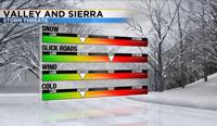
I would not put away your winter gear just yet. A modest storm will move through the region Friday and Saturday. Not a lot of snow will fall, but it will be enough to cause delays and problems on our mountain roadways. Less than an inch of snow will fall in the valley, but only a dusting can make roads slick.
A Winter Weather Advisory has been posted for the Sierra beginning Friday at 4pm and going through Saturday at 1pm.
An advisory is not as dangerous as a warning, but means there will be some travel problems, and one should be prepared. An advisory has not been issued for the valley, but some light snow is possible in the Reno area as well.

This is a unique set up with a few storms moving through the region, but not all of them will make a direct impact.
A long area of low pressure is splitting in two as it reaches the California coastline. The southern branch could give areas south of Highway 50 and in the mountains a chance for light snow Thursday night, but most of our area will stay dry. The northern branch of the trough will stay over the Pacific northwest for much of Friday, before a cold front moves through the region Friday night. The front will come from the northwest impacting both the Sierra and valley. This looks very similar to an inside slider, but appears to be too far to the west to be totally classified as one.
There will be some moisture to work with, but not a ton. Totals would be much higher if there was a channel of moisture leading up to the low, but instead it will be coming in from the northwest off the shore of Oregon. Precipitable water values are not high, but there will be higher relative humidity and dewpoint values.

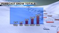
Snow totals will range from less than an inch in the valley, to 1-3 inches in the hills, 2-5 inches at lake level, and over several inches in the high Sierra.
Most of the snow will fall Friday night into Saturday morning. Thundersnow is also possible Friday evening, which would make snow totals even higher in localized areas.
This is a tricky forecast, but there is a good agreement that a low will move in Friday night bringing snow to both the valley and Sierra.
Saturday afternoon will be cold with highs in the low 40’s and a few scattered showers. The main band will wrap around the backside of the low and move east along with the low throughout the day on Saturday.
Winds will be strong Friday, especially in the afternoon and evening hours before the front moves through. Gusts will range from 40mph in the Truckee Meadows to 80mph in the high Sierra. The wind direction will go from the west Friday to the northeast behind the low Saturday night and Sunday.