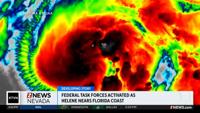


Forecasters say Helene has strengthened into a Category 4 hurricane as it races toward northwest Florida.
The enormous storm is expected to make landfall Thursday night.
Category 4 hurricanes have sustained winds over 130 mph that can severely damage homes, snap trees and down power lines.
Strong winds have already cut power to over 250,000 homes and businesses in Florida.
Authorities warn that storm surges of up to 20 feet could also wreak catastrophic damage.
Helene is also expected to damage large swaths of the southeastern U.S. as it moves inland.
Hurricane warnings and flash flood warnings extend far beyond the coast up into northern Georgia and western North Carolina.
Along Florida's Gulf Coast, school districts and multiple universities have cancelled classes.
Helene had swamped parts of Mexico’s Yucatan Peninsula on Wednesday, flooding streets and toppling trees as it passed offshore and brushed the resort city of Cancun.
The storm formed Tuesday in the Caribbean Sea. In Cuba, the government preventively shut off power in some communities as waves as high as 16 feet (5 meters) slammed Cortes Bay. And in the Cayman Islands, schools closed and residents pumped water from flooded homes.
Helene is forecast to be one of the largest storms in breadth in years to hit the region, said Colorado State University hurricane researcher Phil Klotzbach. He said since 1988, only three Gulf hurricanes were bigger than Helene’s predicted size: 2017’s Irma, 2005’s Wilma and 1995’s Opal.
Areas 100 miles (160 kilometers) north of the Georgia-Florida line can expect hurricane conditions. More than half of Georgia’s public school districts and several universities canceled classes.
For Atlanta, Helene could be the worst strike on a major Southern inland city in 35 years, said University of Georgia meteorology professor Marshall Shepherd.
Landslides were possible in southern Appalachia, and rainfall was expected as far away as Tennessee, Kentucky and Indiana.
Federal authorities have positioned generators, food and water, along with search-and-rescue and power restoration teams.
Helene is the eighth named storm of the Atlantic hurricane season, which began June 1. The National Oceanic and Atmospheric Administration has predicted an above-average Atlantic hurricane season this year because of record-warm ocean temperatures.
In further storm activity, Tropical Storm Isaac formed Wednesday in the Atlantic and was expected to strengthen as it moves eastward across the open ocean, possibly becoming a hurricane by the end of the week, forecasters said. Isaac was about 690 miles (1,115 kilometers) northeast of Bermuda with top sustained winds of 50 mph (85 kph), according to the hurricane center, which said its swells and winds could affect parts of Bermuda and eventually the Azores by the weekend.
In the Pacific, former Hurricane John reformed Wednesday as a tropical storm and strengthened Thursday morning back into a hurricane as it threatened areas of Mexico’s western coast with flash flooding and mudslides. Officials posted hurricane warnings for southwestern Mexico.
John hit the country’s southern Pacific coast late Monday, killing at least two people, triggering mudslides, and damaging homes and trees. It grew into a Category 3 hurricane in a matter of hours and made landfall east of Acapulco. It reemerged over the ocean after weakening inland.
(Copyright 2024 The Associated Press. All rights reserved. This material may not be published, broadcast, rewritten or redistributed without permission.)