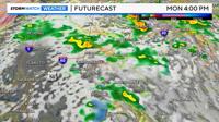
After a hot and dry summer, there is finally a good chance of showers and storms in northern Nevada. The rain will favor central and eastern Nevada, but some rain will expand westward from time to time as well. The rain will come in bands/rounds and pinwheel around the low. As the low comes out of the southwest initially, most of the rain will fall to the west of Reno to begin with. Some thunderstorms are possible Monday morning in the Truckee Meadows as well. If that happens, the air will cool much quicker, and some light snow could fall at Donner.
Another chance for rain in Reno comes Monday evening as another band rotates around the backside of the low, and moves south from the north. The rain will be light to moderate, and a few thunderstorms are possible as well. Higher amounts of rain will fall in thunderstorms.

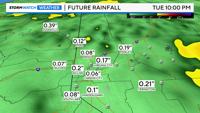
Rain totals will exceed a tenth of an inch for east Reno and Sparks, and top a quarter of an inch in central and eastern Nevada. Rain totals will vary due to thunderstorms. This will be a good wetting rain, with most spots receiving rain, but not 100% widespread. Snow totals will be less than a few inches, with a snow level above 6500’. Travel impacts will be low due to a warm ground.

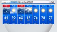
A stronger system will move into the region early Wednesday. This storm will have more moisture to work with and less wind. This one will be just as chilly, with more widespread rain, and higher rain totals. Rain showers persists through the first half of Thursday before drying out on Friday. The models have been in agreement about these storms and there is high confidence.