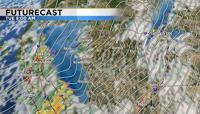

A significant storm will move through the region late Sunday through Wednesday. The majority of the snow will fall in the Sierra but some of it will fall in the valley too. A Winter Storm Warning has been posted for the Sierra from Sunday afternoon through Wednesday morning at 4am. Multiple feet of snow will fall in the mountains, and visibility will be low at times. Travel is not advised. A strong area of low pressure is moving in from the west northwest, gathering moisture and has plenty of dynamics to create snow this week. A storm that sits in the ocean can gather more moisture than a storm that just travels over land. The storm is large in size, which means it will take a while to get out of here.


The Monday morning commute will be slick in spots but not areawide. Temperatures will range from the mid 30’s at the Reno Airport to 32 degrees in the hills Monday morning. Snow can form with temperatures above freezing, but the ground is still quite warm and there won’t be enough snow to accumulate on the pavement in the lowest elevations. It will be slick in places like the North Valleys and Galena Monday morning. There will be a break in the snow late Monday morning with another round moving in early Tuesday. The snow in the Sierra will come in waves Monday, with periods of white out conditions and slick roads.

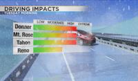
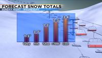
The second round will come out of the southwest rotating around the low on Tuesday. Roads will be slick at all elevations Tuesday morning, with is election day. The best time to vote in person will be late Tuesday morning into the early afternoon. Another round will move in from the southwest Tuesday evening. With the bands coming out of the southwest South Lake Tahoe will see more snow than Incline Village. Carson City will also see more snow than Reno. Snow totals will range from a few inches at the Reno Airport, to several inches in Carson City and the hills including Virginia City. Lake Tahoe will get a couple feet of snow by Wednesday morning and the crest could see over three feet. Wednesday morning will be slick too with a few lingering snow showers and icy patches.

Valley wind speeds will be strong Sunday night through Monday morning, gusting in the 50’s. Ridge tops will see wind gusts near 100mph into Monday morning, blowing snow around and leading to whiteout conditions. While it will still be breezy Monday afternoon, gusts won’t be quite as strong as in the morning. By Tuesday morning wind speeds will be in the teens, but the snow will be heavier.


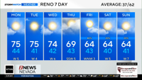
Temperatures will be in the 40’s this week which means there will be some melting during the day, but mornings, evenings, and nights will be messy for drivers in the valley. Expect rough conditions in the mountains during eighty percent of the storm. The low will be out of here Thursday but the cold air will stick around for a while. Lows Thursday morning will be in the teens and lower 20’s. Stay warm and safe. Follow me on Facebook at KTVN Angela Schilling for more weather information. You can also follow me on Twitter, Instagram, and Tik Tok at Angela Schilling.