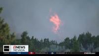
Snow is still possible this weekend in the valley, especially for areas south of I-80. This won’t be a huge storm, but there will be impacts. Watch the video below for a more in depth discussion.
The models are differing on totals and timing slightly, but the heaviest snow will develop south of I-80. This means Carson City will see more snow than Reno, and the North Valleys will see less snow than the airport. This will be a cold enough storm to only fall as snow.
It will be breezy too, with a Wind Advisory posted for the western side of the Sierra from 10pm Friday through 10am Sunday morning, where wind gusts could reach 55mph.
A Winter Weather Advisory is posted for central California near Yosemite from 10am Saturday through 4pm Monday.

Temperatures will hover around freezing Saturday afternoon, with a lot of us staying below 32 degrees, which means roads will stay slick throughout all of Saturday. There will still be some icy spots Sunday morning, with some improvement Sunday afternoon.
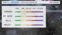
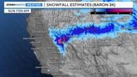
Snow totals will range from over several inches near Yosemite, to a couple inches in south Reno, and 2-5 inches in Virginia City. Carson City could see 1-3 inches by Sunday morning. Driving impacts will be low for Donner, but medium for the Truckee Meadows.
Stay tuned for more weather updates.