A fast moving storm will slide down the California coastline Friday night into Saturday morning.
As of now, snow totals appear to be light, but we’ll have to watch this one closely as it has potential to produce more snow than anticipated in the mountains, and some light accumulating snow in the valley. A second storm will move through around Valentine’s Day dropping temperatures significantly.
Snow totals will be even lighter with this storm, but it will be much colder and breezy.


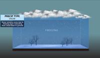
So, how does snow form? There are a lot of different factors that goes into it, but the basic concept explains snow as multiple ice crystals that are bonded together.
They start out in clouds, and when the cloud gets heavy enough it snows. The temperature profile from the cloud to the ground determines what precipitation type will fall. Snow can actually fall when the temperature is slightly above 32 degrees.
While the snowflake will start to melt when it reaches 32 degrees, it can hold enough of its structure to still be considered snow until the air temperature reaches approximately 2.4 degrees Celsius or when the melting layer is nearly 4000 feet long.
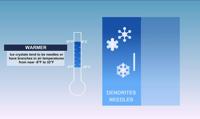
The temperature also determines what kind of snow is falling. Warmer snow holds more water and can produce bigger flakes, while colder, dryer snow is lighter and fluffier. Colder snow piles up easier and can lead to higher snow totals: this is great for skiing, but not for building snowmen.


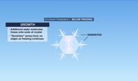
In order for snow to form, it needs some sort of nuclei like dust particles for the super cold water droplets to freeze on. As more super cold water droplets freeze on the dust particle, a crystal begins to form and take on a hexagonal shape. As more water droplets stick on the crystal, dendrites begin to form on each end. Dendrites looks like arms coming out of the outside of the crystal.

Temperatures colder than eight below Fahrenheit leads to crystals that resembles plates or columns. Warmer crystals ranging from -8° to 32° Fahrenheit leads to crystals that resembles needles or dendrites, with arms sticking out of the center... kind of like a flower.

The wet bulb temperature can also determine whether or not snow can form. That was the case this past weekend when temperatures reached the low 40s but the wet bulb temperature was forecasted to be below freezing. The wet bulb temperature is found in between the temperature and the dewpoint, and is the temperature that will be reached when evaporative cooling occurs in unsaturated air.
Snow totals ranged from about 1-3 feet in the Sierra to mostly less than an inch in the Reno area last weekend.
Most of the snow fell Saturday night in the Sierra, with accumulating snow in the valley around sunrise. The Reno area did fall below freezing Sunday morning when most of the snow fell in the valley.