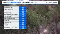
Wednesday was not quite as windy as last week, but a close second. Peak wind gusts topped 40 mph throughout much of Reno on Wednesday, and 50 mph in the western Basin and Range. Blowing dust was also a possibility. Strong winds can develop in front of a system, but they can also develop on the backside of one. That is what happened on Wednesday.
A change in temperature changes the pressure, thereby tightening the pressure gradient. The tighter the pressure gradient, the stronger the wind gusts will be. Living in a mountainous area, elevation can also play a role. Highs on Tuesday were in the mid-60s, the upper 50s on Wednesday, and close to 50 degrees on Thursday. This is enough of a pressure and temperature change to increase wind speeds.


Winds usually change direction behind a front as well, coming out of the west or southwest before the front moves through, and then turning more northerly behind it. For much of the country, a southerly wind is common before a front moves through.
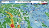
Wind directions are not as uniform in mountainous areas. By late Friday and Saturday, winds will be coming more from the northeast. An east wind creates a downsloping effect in the Sierra, especially on the west side of Tahoe. While wind speeds will be lighter this weekend in Reno, they will be strong in the Sierra as a result.

An east wind typically develops as an area of low pressure moves east, causing the wind to wrap around the existing low in a counterclockwise fashion. Strong winds can make it feel colder than it actually is and can also increase fire danger, especially if the air is very dry.