
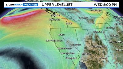
High pressure has been the star of this week so far, with highs forecasted into the upper 80s by Tuesday. Before long however, we’ll be shifting into a pattern of zonal flow, and our warming trend will basically stall and plateau for the remainder of the work week. If you’re wondering what any of this means I’m here with an explanation for you. Typically, we are used to upper level troughs which bring cooler air and high pressure ridges which bring warmer weather. Zonal flow is a more neutral mode of the atmosphere where the winds in the jet stream flow west to east with little or no deviation. The result of zonal flow is that typically the weather patterns around the flow don’t change very much, and warmer air stays south of the flow and cooler air says north. Storms travelling via zonal flow also move quicker but don’t deviate much in path.
Because we’ll be on the southern end of this zonal flow this week we can expect highs to remain in the upper 80s or around 90 throughout the rest of the work week. We will move out of zonal flow when an upper level trough swings in from the Gulf of Alaska and cools us down for the weekend. Hopefully that quick explanation about zonal flow helps. Have a great day!