

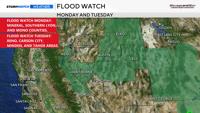
A flood watch is up for Monday and Tuesday due to the potential for flash flooding. The watch on Monday only includes Mono, Mineral, and southern Lyon Counties and goes through 11 p.m.
The watch for Tuesday also includes the Truckee Meadows and is also for the possibility of flash flooding.
Now is the time to clear any debris from storm drains. The flash flooding won’t be widespread, but it is possible.

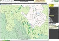
Values over an inch are very high for our area, indicating we have plenty of water or moisture to work with.
The moisture is coming in from the south, which is wrapping around an area of high pressure to our east over the Four Corners.
This is a monsoonal weather pattern, which is defined as a seasonal reversal of winds. Usually, our winds come out of the west in Reno, but with a monsoon they come out of the south.
A slight change in wind direction from south to southwest makes a big difference in whether we stay dry or wet.
A monsoon pattern can also create a narrow band of storms, leaving a thin line between heavy rain and hardly anything.

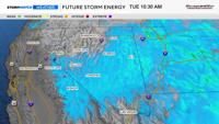
The amount of instability we have plays a big role as well. Storms like boundaries, and one boundary to pay attention to is the division between dry stable air and moist unstable air.
For now, the boundary is just east of Reno and south of I-80. That is where the majority of the storms are developing Monday afternoon. While they will creep to the north as the evening progresses, they will weaken as they do.
Tuesday will be the most active day of the week, as storm chances include areas to the west and instability increases.
The second day can be more active, as the atmosphere becomes more saturated.
CAPE values will be high enough for thunderstorms on Tuesday, and with the boundary line moving west, Reno will have a better chance of seeing thunder and lightning.
Precipitable water values are also high, indicating we have plenty of moisture or water to work with.

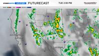
The showers will come and go and will develop in the afternoon and evening hours, starting as early as 12 p.m., especially south of I-80.
Some showers and storms are possible Monday night as well, but they won’t be as strong.
Rain totals will vary greatly, but downpours are certainly possible. Rain totals could reach a half inch if you get underneath a strong thunderstorm.


Flash flooding will be the main hazard with any storms that do develop, but gusty winds and fire starts outside of the rain cores are possible too.
Hail is possible, but chances are low.
Fire risk is not incredibly high, as the storms will be rain producers, but the threat is not zero either. The trick is to get the rain lined up perfectly with the lightning.


Drier air starts to move in on Wednesday, but a few showers and storms are still possible, mainly east of Reno.
Thursday is trending much drier and hotter, with highs in the upper 90s.
The placement of the high over the Four Corners changes the wind direction over here, therefore impacting whether we get moisture or dry air. A west wind provides us with dry air.