

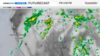
You’ll need a rain jacket all day on Friday, with most of the rain falling in the late morning or afternoon. There is a slight chance during the morning commute as well. There will be a few breaks, but not very many.
Finally we have a chance for rain this week, and it will be a nice light to moderate rain with an isolated rumble of thunder. The rain arrives Friday morning and sticks around through the afternoon. No severe weather is expected. It won’t be raining the entire day with a few breaks here and there, but not very many. Cooler air moves in on Friday as well, with highs in the 80’s over the weekend.


We’ve been stuck between a ridge to our east and a trough to our northwest for days, keeping us in a dry, windy pattern for a while. The southwesterly flow comes on the underside of the trough, with a slight shift in the location of the high changing the wind direction to out of the south. The ridge will move slightly east on Friday, allowing for the trough to get a little bit further southeast, and the rain will develop along the outside of the trough from southwest to northeast. There is some moisture in the ocean to our southwest, and we will be able to tap into it on Friday.

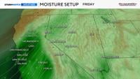
The forecast is a close call for who will get the most rain. A narrow band of rain will develop along the jet stream from Lake Tahoe up through Humboldt County, and including Reno. The band also includes Minden, Carson City, and Fernley. The showers will be heavier and more scattered in central and eastern Nevada Friday afternoon, opposed to the narrow band to the west.

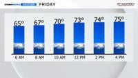
No severe weather is expected, but a stray thunderstorm can’t be ruled out. Cloud cover will keep cape values at bay. CAPE is how much instability we have, which is food for storms.

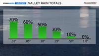
No flooding is expected, but around a few hundredths of an inch to quarter of an inch will fall on Friday. The rain will be light overall, with pockets of heavier downpours. Some spots especially south of I-80 and west of US-95, will see more steady persistent rain and higher totals. Rain totals will also be higher if you get underneath a thunderstorm.
Drier air moves in behind the front on Saturday, clearing us out and making for a sunny weekend. Highs on Saturday will be in the mid 80’s with wind gusts up to 40 mph. Wind speeds will be lighter on Sunday. Make sure to be fire aware this weekend.
