

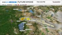
Plan on it being smoky Friday morning in the Truckee Meadows, before conditions improve in the afternoon. Smoke and haze can be dangerous to breathe in, especially if you are sensitive to it. There are a lot of different components that go into a smoke forecast, primarily the wind. Both wind direction and speed play a role. Typically, you want strong winds to break up the smoke, but if the wind is coming from the fire, then it can bring more smoke into the area as well.

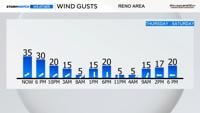
The wind direction will be coming out of the west or southwest through late Thursday, before turning out of the north late Friday morning. A west wind will carry the smoke into the Reno area late Thursday, before a north wind pushes it south of Reno late Friday morning. Smooth sailing by Saturday as the low moves out of here and the flow comes out of the east. An east wind will push the smoke further into California.

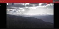
There is less smoke from the Floriston Fire Thursday afternoon, but there are still some hot spots. Which is why we are not out of the woods just yet.
The strength of the fire is the main player in whether we see smoke or haze Thursday night. While the fire appears to be putting out less smoke, there are still some hot spots. Winds will also be strong through early Thursday night, before easing after 9 pm. If crews can really get a handle on things Thursday night, then the smoke would be less Friday morning.

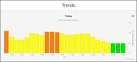
Reno’s air quality did reach Unhealthy for Sensitive Groups late Wednesday into early Thursday, but dissipated pretty quickly. Friday will be similar, with less smoke by early Friday afternoon. Especially once our winds come out of the north.
