

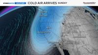
Not only will it be cooler this weekend, but there is also a chance of snow in the High Sierra, rain in the valley, and strong winds.
Temperatures will be 25 degrees cooler on Monday compared to Friday. The snow level will drop to roughly 7,500 feet on Sunday, with rain below that.
Mono County has the best chance of seeing light snow, where four inches could fall by the end of the weekend.
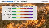
The chance is not zero at Donner, but is less than in Mono County. The flash flood threat is very low in the Truckee Meadows, but it is possible in southern Nevada.

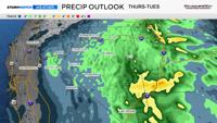
The moisture arrives on Sunday, a day after the cold front moves through the region.
The timing of when the moisture moves in, compared to when the low arrives from the north, will play a big role in how much rain and mountain snow we will get.

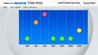
Fire danger will be critical on Saturday due to strong winds, gusting over 40 mph, and low relative humidity values. There will be a slight increase in moisture ahead of the front, but not enough to combat the wind.
Our fuels are also still very dry. Put all of the ingredients together, and there is a Fire Weather Watch up for the Sierra Front, including Reno, Carson City, and Minden from Saturday morning through the evening hours.
If confidence grows, the National Weather Service will replace the watch with a warning.

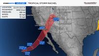
There are two pieces to the puzzle on Sunday: an upper-level low and the remnants of Tropical Storm Rachel.
The upper-level low provides us with lift and energy, and the remnants of Rachel provide us with moisture.
A cold front moves through on Saturday, with cooler air moving in behind it over the weekend.
Southern Nevada and eastern Nevada will see much more rain than western Nevada and areas north of Highway 50.
More rain will fall in eastern Nevada because that’s where the remnants will be early next week.

Rachel will weaken quite a bit once it crosses land on Sunday, losing its tropical characteristics.
There is a slight chance Las Vegas will see flash flooding on Sunday, with rain amounts exceeding flash flooding guidance within 25 miles, or a 15% chance.
Areas just to the north of Las Vegas, in places like Tonopah, have a marginal chance of 5%.
