

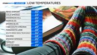
For the first time in the past two weeks, temperatures fell below freezing at the Reno Airport.
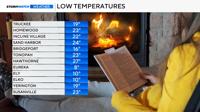
While Reno reached 30 degrees, it was even colder throughout much of Northern Nevada. Eureka, Nevada, even reached eight degrees Friday morning.
Many neighborhoods within Reno itself were in the lower to mid-20s around sunrise.


It would have been even colder if wind speeds were lighter.
Calm winds make it easier for cold air to settle into the valley, and make it tougher for warm air to mix down.
Strong winds mix up the air by creating eddies or circular motions, bringing cold air upwards and warm air downwards.

Wind gusts between five and ten miles per hour made it feel several degrees cooler than it actually was.
For example, while it was 30 degrees at the Reno Airport on Friday at 6 a.m., wind speeds were roughly 8 mph, and the wind chill was 23 degrees.
Reno’s last hard freeze of 28 degrees or cooler was on March 7th. Granted, we still have time for another cold spell to slip in here.
Our cold fronts can be well defined, but they are typically harder to make out than east of the Rockies, where you can find classic mid-latitude cyclones.
For those along the west coast, fronts tend to get shredded apart.
The image and video below show much warmer air east of Colorado and cooler temperatures to the west. This strong cold front will be the focal point for severe storms on Friday.
A cold front marches across the United States, with pockets of freezing temperatures in the west Friday morning. The clock is in Pacific Time.