

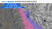
Keep your winter clothes handy, another round of snow is in the forecast this week. Winter Storm Warnings are up for the western side of the Sierra as well as advisories for the Tahoe Basin beginning early Tuesday morning and going through Wednesday afternoon for heavy snow and slick roads. Pack chains and patience if you plan on traveling in the mountains during this timeframe.
NDOT is reporting chain controls are in place on I-80 from Donner Lake to Kingvale.
Drivers should be prepared for weather changes and impacts to travel.
Breaking down our next winter storm, with snow likely in the Sierra. Winds will be strong in parts of Nevada.
There will be some shadowing due to the track of the low and southerly flow. This means more snow will fall in the western Sierra opposed to the eastern side of Tahoe. This is why there is a Winter Storm Warning for the western slope of the Sierra and an advisory for the Tahoe basin.


Travel will be worse at night due to colder temperatures and a better chance of the snow sticking to the pavement. A higher sun angle slows down how quickly the snow can accumulate on pavement. When a good snow band moves through, the snow can still accumulate on roadways despite warmer ground temperatures. As the low moves over land, the snow will pick up in intensity late Tuesday, lowering visibility and increasing the odds of slick roads.
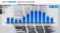
Travel impacts range from low Monday night to medium Tuesday morning on the western side of the Sierra, then dropping to low from 10 a.m. to 1 p.m. Tuesday before rising again to medium through Wednesday morning. Wednesday afternoon impacts ease back to low as snow showers become more scattered.

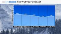
The snow level starts near 6,800 feet Tuesday morning, dropping to around 6,200 feet during the day. By Wednesday morning, snow levels reach foothill elevations, though precipitation becomes more spotty at that point.

Donner Summit will be slick Tuesday morning, with improved conditions between 10 a.m. and 1 p.m. due to a higher sun angle, followed by worsening conditions into the late afternoon and overnight hours.
Mt. Rose Highway conditions are being affected by shadowing. Much of Tuesday may remain manageable, but conditions are expected to deteriorate by around 3 p.m., with hazardous travel continuing overnight into Wednesday morning.
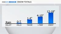
The valley will see a mix of wind and rain with this system. Rain will be intermittent Tuesday, with totals ranging from a few hundredths to a couple tenths of an inch. Reno will see west winds between 5 and 15 mph with gusts up to 25 mph, while stronger winds in the western Basin and Range may reach 60 mph.

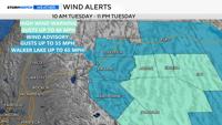
A High Wind Warning remains in effect until 11 p.m. Tuesday for White Pine, Southern Lander, Southern Eureka, Northwestern Nye, and Northeastern Nye counties. Sustained winds of 35 to 45 mph with gusts near 60 mph are expected, with blowing dust and reduced visibility in some areas.
Wind Advisories are also in effect for western Nevada Basin and Range areas including Pyramid Lake, where gusts up to 45 mph are expected and lake conditions will be hazardous.
Gusty winds are also expected east of Highway 95, with blowing dust reducing visibility at times. Drivers are urged to secure loose outdoor objects and use caution, especially in high-profile vehicles.
In the Tahoe Basin, a Winter Weather Advisory remains in effect through Wednesday afternoon. Heavy snow above 6,500 feet is expected, with 4 to 10 inches common at mid elevations and up to 18 inches on higher peaks. Lake level snowfall of 1 to 4 inches is possible, with the highest amounts on the western shores. In fact, the west side of Tahoe could get up to six inches of snow by Wednesday morning. Gusty winds up to 35 mph at lake level and ridgetop gusts up to 90 mph are also expected.
In Reno, conditions will gradually improve after Tuesday, with scattered showers through early Wednesday morning. Tuesday night brings a chance of lingering rain and snow showers, with snow levels dropping to around 5,000’ feet overnight and a low near 35. Light snow is possible in the foothills early Wednesday, but accumulations will be very light if at all.
Wednesday turns partly cloudy with highs in the mid 50’s, followed by a warming and drying trend through the end of the week with highs climbing into the 60s by Friday.
Travel across the Sierra remains difficult at times, especially during periods of heavier snowfall and overnight hours. Officials continue to urge drivers to check road conditions, carry chains, and allow extra time for travel.