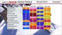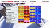
The snow will be light and fluffy, piling up quickly, but not good for making snowmen.
A significant storm is still on track to bring heavy snow to the Sierra and a mixture of rain and snow to the Truckee Meadows through late Thursday evening. Snow is already coming down in the Sierra as of late Wednesday morning, and it’s starting to rain in the valley as well. Wind gusts are exceeding 30 mph in the valley, making it feel even colder in the Reno area.

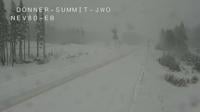
It will be cold enough for snow at all elevations from late Wednesday evening through Thursday morning. Wednesday and Thursday will be dangerous in the Sierra, with travel not advised. Snow levels will drop during the Wednesday evening commute reaching the foothills in places like Verdi and Somersett by 7 pm and the Reno Airport by 10 pm. The snow showers will be scattered overnight before turning more steady Thursday morning. The rain and snow will come in rounds on Thursday as the low begins to move east.
Whiteout conditions are possible due to strong winds, fluffy snow, and snowfall rates between 1-3” per hour.
All of our mountain passes will be impacted.
The snow level will be around 5,500’ during the day on Wednesday and 5,000’ on Thursday.

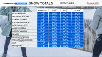

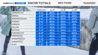
Feet of snow will fall in the Sierra between Wednesday and late Thursday night.
The snow will be steady on Wednesday, with more scattered showers late Wednesday evening, before becoming steady again early Thursday morning.
Another round will move in Thursday afternoon. It will stay slick in the foothills all day Thursday, with improving conditions in the lower elevations as the snow turns to rain.
The mountains will be a mess throughout the duration of the storm.