

Wind is not typically something people enjoy, but it can provide some relief when it’s hot out. Just like many things in life, strong winds have their pros and cons.
In Northern Nevada it plays a big role in fire danger. The wind can also make allergies worse, blow dust around, make it feel colder, increase evaporation rates, and create chop on our local water ways.
On the other hand, wind can also help to mix up the air, improving air quality. Especially, if the wind is blowing in a favorable direction. If the wind direction is coming out of the west where a fire is, then it can make it worse. Calm winds and an inversion creates a very stagnant weather pattern.

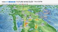
What’s creating the wind today is an area of low pressure moving through the Pacific Northwest. The air is too dry to give us any rain, but it is close enough to cool us down. Wind is related to temperature and pressure differences. Highs were in the upper 80’s and low 90’s on Tuesday, dropping by roughly ten degrees on Wednesday.
Wind gusts will be in the 20’s and 30’s through this evening, however, localized areas could see wind gusts over 40mph. Northeast Nevada could see wind gusts around 50mph where a Wind Advisory is up through 11pm Wednesday evening. A Lake Wind Advisory remains in effect for Pyramid Lake through 8pm Wednesday.

Northern Nevadans should always be fire aware, even if a Red Flag Warning is not issued. It is common for wind speeds to pick up each late afternoon and evening in the Truckee Meadows due to the Washoe Zephyr.
This is a wind that develops during the summer season and is related to temperature and pressure differences between Tahoe and central Nevada. The greater the difference, the stronger the wind speeds will be.