

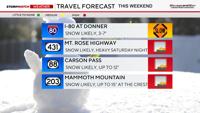
Halloween marks Donner’s first real chance at accumulating snow this season, with several inches possible by Sunday morning.
Moderate to heavy rain is likely in the Truckee Meadows late Saturday into Sunday as well. This will be a decent storm for the end of October, beginning of November.
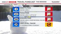
A Winter Weather Advisory goes into effect for the Tahoe Basin at 8 am Saturday and goes through Sunday morning due to winter driving conditions. Our mountain passes will be slick and visibility will be low. Mono County will get slightly more snow than the Tahoe Basin.

After a week of flip flopping the forecast is gaining confidence with spotty light showers Saturday morning turning to more steady and heavy rain in the evening through the overnight hours.
An embedded thunderstorm can’t be ruled out either. The timing of when Reno turns dry is still up in the air, but the consensus is leaning towards 8 am. Showers are likely Saturday afternoon as well, with quite a few of them popping up.

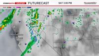

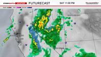
Spotty showers will develop Sunday afternoon mainly in Central and Eastern Nevada as the trough moves east. Saturday night will be active in the Sierra with poor driving conditions. It will be wet in the valley as well. The worst of the storm will be late Saturday night as the system moves east.
Rain and snow totals will vary depending on embedded thunderstorms. Most of the precipitation will be void of thunder and lightning, but if you do get underneath a thunderstorm, it could pile up quickly. This will make snow totals in the Sierra vary quite a bit. In general, the Truckee Meadows and down through Carson City will see between .10-.40” of rainfall over the weekend. Most of the Reno area will get around a quarter of an inch.

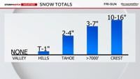
Snow totals will range from 2-5 inches in the Tahoe Basin above 7,000’ to up to 12” at the highest peaks. Mono County will get slightly more snow than the Tahoe Basin, in which the highest peaks could get up to 15 inches by the end of the weekend. Thunder snow can’t be ruled out either and will lead to higher snow totals. Snow will be falling around an inch an hour at the peak of the storm Saturday night.

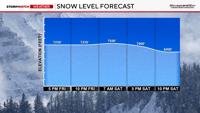
The snow level will be around 8,000’ during much of the day on Saturday, before falling to 6,000’ at 10 pm. It will be cold enough to snow at 5,000’ by Sunday morning, but by then most of the moisture will be east of Reno. However, places like Virginia City could see some light snow before 8 am. No accumulations are expected in the Reno area this weekend.
Kiddos will want to dress warmly Saturday evening. Not only being prepared for rain, but also to stay warm. Temperatures will be in the 50’s for highs on Halloween, and Reno will be in the upper 40’s around sunset.