


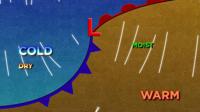

Cold fronts can take us from summer heat to sweater weather in a matter of minutes. You can think of a cold front as a bull dozer. Getting rid of one air mass and replacing it with a different one. The cold front is the leading edge of a colder air mass moving in. We’ve been in the 80’s for a while but we’ll be in the upper 60’s and low 70’s by Sunday. Lows will be in the 40’s. Normally, we’re in the mid 70’s this time of year.

"It's supposed to get cooler this weekend with temps in the 60's. What are your thoughts about that? Oh I'm just very much looking forward to it,” said local resident Halie Meinners.
The timing, strength, and direction of the front is key to getting the forecast right. This can be difficult to do in our area. Fronts are easier to predict when you can follow them. What's happening to the north or west of us can be expected in our area 24 hours from now. For example, if you live in Dallas, Texas you can look towards western Texas, and what they are getting now, will be at your front door in a day. But since our fronts often times come from the ocean, we have nowhere to compare the air mass to. Fronts also don't like rough terrain or turbulence. The friction from the change in elevation tends to split the storms in half with some energy moving north and some moving south. Models are getting better at handling this, but there is still some room for improvement.
A setup like ours can lead to a wide range in snow or rain totals. For example, if a front fizzles out just south of I80 that means areas to the north could get a lot of snow and have poor driving conditions, while others would get hardly anything. Temperatures could vary too.
"It's great the smoke is clearing up and it's cooling down a little bit. So hopefully it gets cooler,” said Meinners.
Same can be said for smoke and wind forecasts. One part of the viewing area could see a wind shift and clear skies while others could be breathing in bad air. Typically, winds come out of the south before a front moves through, and then switches out of the north behind the front. You can’t always go by wind direction in our area because of the change in elevation. Rarely do we see uniform wind directions in northern Nevada. Pressure is related to elevation changes, and wind is directly impacted by pressure.
Warm fronts are known for producing dreary, slow paced light to moderate rain. This would be a great solution for putting out fires. However, our lows are usually not developed enough to have both a cold front and warm front. Instead we usually get a quick hit of rain or snow along a cold front, and that’s about it.
