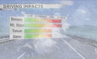
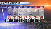
The Monday morning commute will be very challenging both in the valley as well as the Sierra. A Winter Weather Advisory has been posted for the Truckee Meadows and goes from 5am through 7pm Monday. The storm moves out of here late Monday, but roads will still be slick through Tuesday morning. Very cold air will move in behind a front Sunday night so make sure to bundle up. Highs this week will be in the 30’s with lows in the single digits Tuesday morning. stay safe when out on the roads and protect your pipes because of the cold.

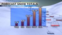
This next storm is coming from the north northwest, similar to what moved through Christmas night. At the height of the storm, snowfall rates in the Sierra will reach 2-4 inches per hour. That is very impressive and will lead to 1-3 feet of additional snow by Monday afternoon. This will be a colder storm allowing the snow ratio to be higher. Colder snow is less dense and has an easier time piling up than wet dense snow. Lighter, colder snow is also easier to blow around. Winds speeds will be a little lower Monday, but still strong enough in the Sierra to lower visibility. Snow totals will range from 1-3 feet in the high Sierra, to 10-18 inches around Lake Tahoe, 4-8 inches in the hills, and 1-4 inches in the lowest elevations. Places like Dayton and Fallon could also see some light snow Sunday night, but amounts will be very light. Ice will be a bigger concern there. Just over an inch of snow fell at the Reno Airport Christmas Day/night to count for a white Christmas. More snow fell after midnight, but that counts for the next day.

Roads will improve by late Monday morning, but the slush will turn to ice after dark. This means that both the morning and afternoon commute will be troublesome Monday. With temperatures falling below 15 degrees Tuesday morning, it will take a while for roads to completely clear. Sierra valleys with lots of snow on the ground could very well fall below zero at night this week. Any wind at all will also make it feel colder. Snow is a good reflector of the sun’s energy but a terrible absorber. This means that snow covered areas are usually colder than dry ones. Freezing fog is always a possibility after a big winter storm, but with clouds hanging around I’m not too worried. Stay warm and stay safe.