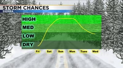
A couple more storms are expected to move through the region this weekend. Keep in mind with the coronavirus we are urged to stay home anyways. Coming in close contact with first responders would put them at risk if you have the virus. A Storm Watch has been posted for the Sierra from Saturday afternoon through Monday morning.


The snow will be slushy but could be heavy at times. Snow totals will range from six to 12 inches around Lake Tahoe to a couple feet in the High Sierra. The valley will just see a mix of rain and snow and roads will stay fine.

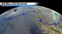
There are a couple different waves that will move through this weekend. The first one is weaker and will be lacking moisture. This one moves through mid-morning Saturday and the stronger one moves through Sunday and Monday. During the day Saturday, the snow will be slushy and may very well melt as it hits the road. At night however, it will be slick and the snow will stick to the ground. Visibility could be low as well. The second wave is the one that will pack the punch. The worst of it will be late Sunday into Monday morning. Forecasting is like a puzzle and you need both pieces at once to get snow. The timing of the moisture matching up with the low itself is hit and miss. The low will stay in a similar location through late Monday. Then it will move south Tuesday. The low will also keep us chilly with highs slightly below normal.
Wind speeds will also be strong this weekend. Gusts will be in the upper 30’s in the valley and over 40 miles per hour in the Sierra.
