The storm gate is open when a lot of people are planning on traveling this week for Christmas.
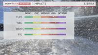
A Winter Weather Advisory is posted for the Sierra, including northeast California, the Tahoe Basin, and Mono County through 7 pm Tuesday. This is a fast storm, with a good amount of moisture and plenty of wind. We’ve seen stronger storms before, but this will be a decent one with high impacts, especially since a lot of people will be traveling. A warning is more dangerous than an advisory, but still means caution.

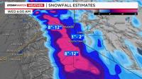
Majority of the rain and snow is developing in front of a cold front, that will move past Reno by late morning, early afternoon. This is when the rain and snow will be at its heaviest. The snow level will fall to 5500’ by 9 pm Tuesday, but by this time most of the moisture will be gone. Roads will be wet in Reno today and this evening, with any puddles evaporating before reaching freezing early Wednesday morning. Virginia City is the one exception that could see light snowfall in the Reno area on Christmas Eve.

Wind is another impact with this storm. A Wind Advisory is posted for the Truckee Meadows through 3 pm Tuesday, as wind gusts could top 40mph. They’ve already reached 50 mph at the Reno Airport Tuesday morning. Wind gusts could top 80 mph at the ridgetops. Strong winds will also lower visibility along our mountain passes because of the snow. Wind speeds will ease behind the front later this evening.

Snow totals will reach a foot in the high Sierra at the Crest, especially south of Lake Tahoe. Only a couple inches of snow will fall at lake level, and 8-12 inches could fall above 7000’. Nothing more than a dusting could accumulate in Virginia City.
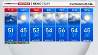
Christmas Day will be dry, but another system arrives late Thursday into Friday morning. Stay safe and have a Merry Christmas.