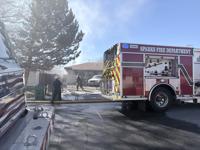
Another strong atmospheric river will move through the region Monday through late Tuesday. This gives the Truckee Meadows a chance for both heavy rain and snow. A Winter Storm Watch is posted for the valley, beginning early Monday and going through Tuesday afternoon. A watch means the ingredients are there, but it’s just something to watch at this point. A warning means it’s happening. The snow level will not be as high as it was with our last storm initially, but it will be low enough for runoff. Daytime highs will be in the 40’s on Monday, but overnight lows will be in the 30’s. Not only is there the possibility for snow Saturday night in Reno, but Monday and Tuesday morning as well. Atmospheric rivers provide the west coast with a lot of water content, so whether it falls as rain or snow it will be heavy with a lot of liquid.

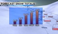
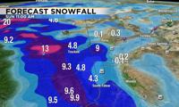
The atmospheric river will be coming from the southwest early Monday morning, and aimed right us. This will make it much easier for the precipitation to spill over to the valley. This will also allow for heavy snow in the mountains. Snow totals will range form 1-2 feet above 7000’ this weekend, to 2-5 feet Monday through early Wednesday morning. Tahoe will see 6-12 inches of snow late Saturday into Sunday, with 6-15 inches possible Monday through early Wednesday. The hills could see up to three inches of snow through early Sunday morning, and several inches Monday through Wednesday. Virginia City could see over a foot by Wednesday. Not expecting a lot of snow below 5000’, but up to an inch of snow could fall by late Sunday morning, and another three inches by Wednesday. Rain totals will be higher in the valley, especially during the day.

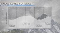
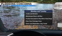
Make sure to clean out any drainage areas before Monday, as this could lead to flooding. As rain falls on top of ice and snow, it will be running down our hills and into our creeks, streams, and roads. The Truckee will rise quite a bit the next few days, but the latest forecast keeps it below action stage. If the snow level stays higher than expected and Reno misses out on the snow, the possibility for flooding gets higher. Snow levels will drop Monday morning to about 4700’, before rising again during the day. Lake Tahoe will see periods of heavy rain and snow, but Donner will see snow majority of the time. The snow level will reach the valley floor again Tuesday morning. While the odds are low, the cold air could get trapped in the valley again Monday morning and have a hard time moving, which would lead to more heavy snow for a long period of time. Just like on New Years Eve. More than likely Reno will see slushy snow early Monday, followed by heavy rain, and then slushy snow again Tuesday morning. Tuesday afternoon will be wet as well with temperatures in the 40’s and rain showers.

Wind speeds will pick up early Monday morning, gusting in the 40’s for the valley and closer to 100mph in the high Sierra. As the rain and snow spills over the wind will get lighter in the valley. Visibility will be low in the mountains when you combine the wind with the snow. Stay safe and stay tuned for future updates.