


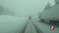

Driving in the snow is dangerous, but spring storms are a little different. By April, the sun angle is higher and the pavement is typically warmer, making it harder for the snow to stick. This usually means less accumulations, especially on the roadway. While snow is common in April, huge storms that significantly help our water supply are rare this time of year. Not all hope is lost though, hydrologist Jeff Anderson says anything helps at this point. Our snowpack usually reaches its peak around April 15th. Unfortunately, our snowpack is already starting to melt.
"We've already lost about a third of our winter snow pack at our snotel sites,” says Anderson.
If it snows hard enough and temperatures are cold enough, the snow can still accumulate. The National Weather Service says huge storms during the winter produces more runoff later on, compared to late season snow storms that falls on bare soils. Which means snow in January is typically better than snow that falls in April after a dry winter.
"As you drive around the mountains you might even notice that on the west facing side, there really isn't even a little snow even on high elevations,” says Anderson.
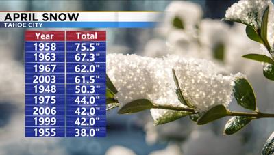
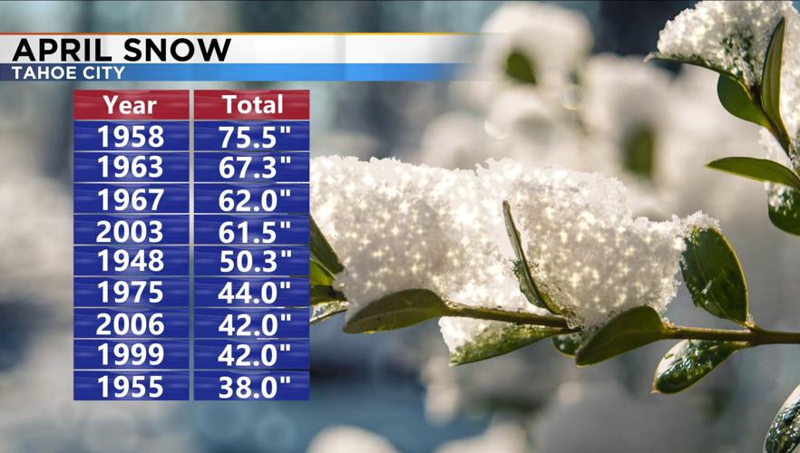
Reno usually sees about a half inch of snow in April, but it’s quite a bit more in the Sierra. Tahoe City received 75.5 inches of snow in April of 1958 and in 2003 they received 61.5 inches. The average is closer to 14 inches. The National Weather Service says more snow in April would not only moisten up our soils and delay the snowmelt, but it could also delay the start of our main fire season.
After reaching the lower 80’s Thursday and Friday, it will be significantly cooler next week. The weekend will be cooler, but not frigid. Highs will be in the mid to upper 60’s Saturday and 50’s on Sunday. The main system will move through the region on Monday. The Sierra could pick up several inches of snow by Tuesday, and even the hills of Reno could pick up a few snow showers late Monday.