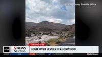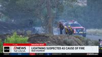


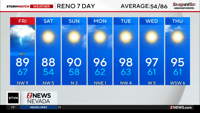

Red Flag Warnings take over the entire state of Nevada Friday with critical fire weather conditions. These are active from 8am through 11pm Friday.
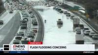
Activity will increase through the late morning and afternoon, with the highest chances across northeast California, the Sierra Front, and much of western Nevada. Some storms could produce heavy downpours, wind gusts up to 60 mph, small hail, and areas of blowing dust. Lightning will also create elevated fire weather concerns, especially where storms produce little rainfall.
Know your evacuation routes and have go bags ready as things can change on a dime with critical fire weather days like today.
By Saturday, most of the storm activity moves out, leaving just a slight chance of a shower near the Oregon border. Temperatures will settle closer to normal for mid-June, with valley highs in the mid-to-upper 80s and Sierra communities in the 70s.
Today's fast-moving thunderstorms could be strong to severe. Possible hazards include hail, strong gusty outflow winds, and lightning. Have multiple ways to receive weather warnings! When Thunder Roars, Go Indoors! #NVwx #CAwx pic.twitter.com/ntZkk5FHP6
— NWS Reno (@NWSReno) June 19, 2026