


Gusty winds and mountain snow could make midweek travel across northern Nevada difficult.
If you have plans on Wednesday evening or Thursday morning, you may want to plan a little extra time.
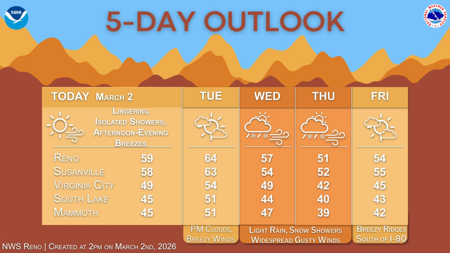
The National Weather Service in Reno says dry conditions are expected Tuesday with slightly warmer daytime highs before a midweek cold front moves through.
In Reno, Tuesday will be sunny with a high near 61 and a south wind around 10 mph. Clouds increase Tuesday night with a low around 35.
On Wednesday, a 30 percent chance of rain is expected mainly between 10 a.m. and 4 p.m., with snow levels around 6,500 feet. The high is expected near 55. Winds will increase from 10 to 15 mph to 20 to 25 mph in the afternoon, with gusts as high as 40 mph.
A cold front moving through on Wednesday afternoon and evening will bring light valley rain, mountain snow showers, and gusty winds. Snow levels are forecast to drop to between 5,000 and 5,500 feet behind the front.
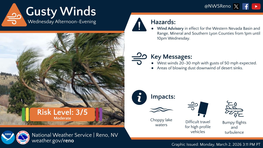
A wind advisory remains in effect from 1 p.m. to 10 p.m. Wednesday for parts of the western Nevada Basin and Range, including southern Lyon and Mineral counties. West winds could gust up to around 50 mph, and Sierra ridge winds could gust up to around 70 mph.
Wind-prone areas along U.S. 395 may see increased crosswinds during the afternoon and evening commutes. Choppy lake conditions, hazardous crosswinds for high-profile cars, and periods of turbulence and wind shear are also expected.
Lingering light snow shower chances of 15 to 30 percent are possible Thursday morning before ending in the afternoon. Highs Thursday are expected in the upper 40s to lower 50s in western Nevada valleys, with Sierra communities in the upper 30s to lower 40s.
Dry conditions return toward the end of the week. Friday is expected to be sunny with a high near 50, followed by mostly clear skies Friday night with a low around 28. Saturday looks sunny with a high near 55.
Farther east, the National Weather Service in Elko has issued a winter weather advisory from 4 p.m. Wednesday to 7 p.m. Thursday for northern Elko County and the Ruby Mountains and East Humboldt Range.
Snow is expected with total accumulations up to 3 inches along Mountain City Highway, up to 7 inches in the Jarbidge Wilderness Area, and up to 11 inches in the Ruby Mountains and East Humboldt Range. Winds could gust as high as 45 mph.
Forecasters say travel could be very difficult. The hazardous conditions could impact the Wednesday evening and Thursday morning commutes. Strong winds could cause tree damage.
Drivers are urged to slow down and use caution while traveling. The latest road conditions for the state can be obtained by calling 5 1 1.
Extended guidance shows temperatures warming into early next week, with parts of western Nevada seeing a 50 to 80 percent chance of highs reaching 70 or above by Monday.