
If you see smoke rising near Reno, Carson City, or the surrounding mountains in the coming months, it may be part of a planned effort to reduce wildfire risk. The U.S. Forest Service is preparing prescribed burns across Northern Nevada and neighboring parts of California, with work expected to continue through May 31 as weather and other conditions allow.
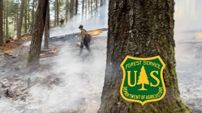
The planned burns include areas near Mount Rose Highway in south Reno, west of Carson City, and in several locations across the Sierra Nevada. Crews will burn piles of vegetation to help reduce wildfire fuels, protect nearby communities and improve forest health.
On the Carson Ranger District, about 156 acres are targeted for pile burning in the Mount Rose Corridor Project area in southern Reno, off Nevada State Route 431, also known as Mount Rose Highway. Another 156 acres are planned for the Arrowhawk Project area, also in southwest Reno along the highway.
West of Carson City, crews are planning burns across about 385 acres in the Clear Creek Fuels Reduction Project area, off U.S. Route 50 in Douglas County.
Other planned work includes about 901 acres in the Dog Valley Fuels Reduction Project area in Sierra County, California, and additional sites in Alpine and Mono counties in California.
The Forest Service uses prescribed fire to remove excess vegetation, reduce wildfire risk, improve wildlife habitat, protect watersheds, and restore ecosystems that depend on fire.
While the work is planned, the timing isn't set in stone. Specialists will evaluate conditions in the days and hours before each ignition. If conditions aren't favorable, burns may be postponed or canceled.
Residents and visitors may notice smoke when the burning begins, but the Forest Service says no closures are planned in connection with the work.
“No closures are associated with this planned prescribed fire activity,” said Jed Rudelbach, fuels specialist with the Carson Ranger District. “However, visitors and residents may experience smoke during the prescribed burns. In the interest of firefighter safety, please avoid the area during active burning.”
The Forest Service says it works with air quality specialists and monitors smoke during prescribed burns, scheduling the work when conditions are best for smoke management. Residents can check current conditions through AirNow's fire and smoke map.
Officials are also asking the public not to report these planned fires. Firefighters will remain on scene during ignitions and patrol the areas afterward.
The Forest Service plans to notify county emergency management officials when burning begins. Residents can follow the forest's websitefor updates on when and where the work will take place.