Roads will stay icy in spots through Tuesday morning, with some improvement Monday afternoon. Conditions are worse outside of the interstate and on main business streets and neighborhoods.
The low is now over southern California, with cold air left in its wake. The flow is coming out of the east, keeping temperatures well below average.
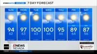
Tuesday morning will be frigid with overnight lows dropping below 20 degrees once again. Some Sierra valleys will even drop into the single digits Tuesday morning. Highs on Monday will be in the upper 30’s, before reaching the 40’s again Tuesday afternoon.
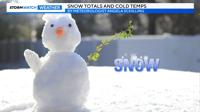
Watch the video below for snow totals.
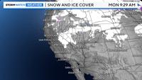
This was a good system for the Eastern Sierra, and a moderate one for the valley. Mt. Rose got 13 inches of snow and Heavenly got eight. Not very much snow fell at Donner or Palisades, as the flow came out of the east instead of the west this time. Only two inches of snow fell at Palisades over the weekend. The Truckee Meadows saw anywhere between one to three inches of snow from Saturday through Sunday. Mammoth Mountain picked up six inches of new powder.

Usually, winter storms come in from the west, but this time around the low came in from the north, with bands of snow coming up from the southeast. It was a combination of both an inside slider and cut off low. The inside slider came late Friday into Saturday morning, and mainly impacted areas well south of I-80. It was the low spinning up bands from the southeast that allowed it to snow in Reno.
While the main upper low stayed to our west, a secondary low was trying to develop close to the surface south of Tahoe on Saturday, with a temperature difference over the state of Nevada. This allowed for bands of snow to move northwest over Reno Saturday night. Moisture was somewhat lacking, limiting snow totals. Snow likes to form on the backside of lows with temperature gradients. This one was unique in that the main upper level low was still to the northwest of Reno on Saturday, which is why I believe this second low that was trying to form south of Tahoe near the surface combined with the temperature difference to the northeast of the low, was helping to spin up snow bands.
Fun fact: the area to the northeast of this weekend's low, with enhanced snowfall is called a deformation zone. The flow around lows is counter clockwise, so the main upper low played a big role as well.