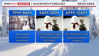
Our storm is on track to bring heavy snow to the valley and Sierra Friday night into Saturday morning. The snow on Saturday will be scattered and come in rounds for the valley, but will be more steady in the Sierra with low visibility. Travel is highly discouraged in the mountains through at least Sunday morning. Chain controls are still likely on Sunday, but the snow will be more showery in nature with longer breaks in between snow bands.

This is a huge storm dropping down from the Gulf of Alaska which means it has a ton of cold air with it. There is also lots of moisture. Combine the two and snow is likely, not only in the Sierra but in the valley too. Once the cold front moves east of Reno Friday night, the snow level will drop to all elevations. As of Friday night at 845pm, there is a mix of rain and snow in the Truckee Meadows depending on your elevation. By 2am the front should be east of Reno. The jet is also aimed right at Tahoe and Reno Friday night, making it easier for the precipitation to spill over.


Behind the front the upper level low will still be able to trigger scattered snow showers in the valley, and steady snow in the mountains. Another band of snow will move in late Saturday evening into Sunday. This will give the valley another shot at widespread snow, but it will be much lighter than Friday night. There will be some breaks in between snow showers on Saturday in the valley. In fact, roads could improve in the Reno area during the day on Saturday, but won’t be perfect, especially in the hills. This will be great snow to build a snowmen, with the right amount of water content.

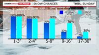
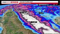
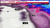
Snow totals will range from 6-12 inches in the valley, over a foot in the hills, and feet of snow in the Sierra. The combination of the heavy snow and strong winds is making this storm an impressive one. The high Sierra, above 7000’ could see between 6-10 feet of snow by Sunday evening. The Tahoe Basin could see one to four. Snowfall rates will top an inch per hour in the Sierra, lowering visibility. Nearly two feet of snow has already fallen at many of our ski resorts.

It will stay windy through Sunday, but the worst of the wind was on Thursday, as gusts topped 50 miles per hour in many spots in the valley. The Blizzard Warning for the Sierra goes through Sunday morning at 10am, and the Winter Storm Warning for the Truckee Meadows goes through 10pm Saturday night. A Blizzard Warning has more to do with poor visibility than snow itself. That being said, a lot of snow will fall in the mountains too. The Monday morning commute will be slick in spots from the leftovers. Stay tuned for more weather updates on air and online.