Snow continues to fall in the Sierra Sunday night, with storm totals in feet not inches. Preliminary snow totals are in and range from a few inches east of Reno to over six feet of snow in mountain communities. Reports are from observation sites, viewer reports, and weather watchers across the area.
Valley roads will be slick Sunday night because of light snow and ice. Travel is still discouraged along our mountain passes. Monday will be better in the Sierra, but not perfect. Chain controls are still likely early this week, especially in the afternoon. While it will be slick Monday morning in the valley because of the leftovers, it will be dry.

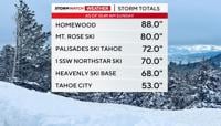
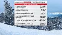
Many of our ski resorts saw over four feet of snow since Thursday. Lake Tahoe saw feet of snowfall too. Tahoe City got over four feet of snow since the storm began on Thursday. Mt. Rose Ski got a ton of snow too. Over six feet, in fact, as of Sunday morning. Homewood got even more than Mt. Rose. The storm reports from the National Weather Service came out just before 11am Sunday morning. Storm totals from viewers vary in time on Sunday.

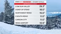
Just over ten inches of snow fell at the Reno Airport since Thursday. Most of it falling late Saturday. It rained at the airport late Friday night before switching over to snow early Saturday, lowering snow totals for the first round.

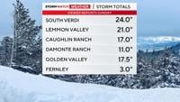
Northwest Reno and Somersett got over a foot, as well as the hills of southwest Reno. Multiple reports show roughly ten inches of snow in Sparks. South Reno below 5000’ also got around ten inches. One viewer says he got nearly three feet of snow in Arrowcreek at an elevation of 5610'.

The snow is hard to measure because of strong winds blowing everything around and creating drifts in spots. More snow will fall in the Sierra through Wednesday, but it won’t be as heavy or steady as this weekend.