IndyCar Indy 500 Auto Raciing
- Michael Conroy - FR172379 AP
- Updated
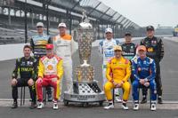
Former winners of the Indianapolis 500 auto race pose at the Indianapolis Motor Speedway in Indianapolis, Monday, May 18, 2026. Front row, left to right, Will Power, of Australia; Josef Newgarden; Alex Palou, of Spain; and Scott Dixon, of New Zealand. Second row: left to right, Alexander Rossi; Ryan Hunter-Reay; Helio Castroneves, of Brazil; Takuma Sato, of Japan; and Marcus Ericsson, of Sweden.
Michael Conroy - FR172379 APTags
As featured on
INDIANAPOLIS (AP) — Alexander Rossi hobbled into his Indianapolis 500 media day interview on…
INDIANAPOLIS (AP) — Scott McLaughlin waited 12 months to erase the worst memory of his life.
Felix Rosenqvist swung to the outside of David Malukas, then found a way past the Team Penske driver to win the closest Indianapolis 500 in history by a margin of 0.0233 seconds. Malukas looked like he was in position to win when he passed race leader Marcus Armstrong off the final restart with one lap to go while Rosenqvist and Armstrong battled wheel to wheel down the back straightaway and through the final turn. Rosenqvist had just enough power to pull away from Armstrong and snake behind Malukas before making the decisive pass in the final 50 feet. The closest previous finish came in 1992 when Al Unser Jr. beat Scott Goodyear across the yard of bricks by 0.043 seconds.
Weather Alert
...RED FLAG WARNING IN EFFECT FROM 1 PM TO 10 PM PDT THURSDAY FOR THUNDERSTORMS AND STRONG OUTFLOW WINDS FOR THE SIERRA FRONT... The National Weather Service in Reno has issued a Red Flag Warning for thunderstorms and strong outflow winds, which is in effect from 1 PM to 10 PM PDT Thursday. * Affected Area...Fire Weather Zone 420 Northern Sierra Front including Carson City, Douglas, Storey, Southern Washoe, Western Lyon, and Far Southern Lassen Counties, Fire Weather Zone 421 Southern Sierra Front including Alpine, Northern Mono, Southern Lyon, and Western Mineral Counties. * Thunderstorms...A mix of wet and dry thunderstorms Thursday afternoon. There is some uncertainty in thunderstorm coverage, but isolated dry lightning will be possible. * Outflow Winds...Gusty and erratic thunderstorm outflow winds, even well away from rain cores. Gusts to around 50 mph possible. * Impacts...Lightning can create new fire starts and may combine with strong outflow winds to cause a fire to rapidly grow in size and intensity before first responders can contain them. PRECAUTIONARY/PREPAREDNESS ACTIONS... Avoid outdoor activities that can cause a spark near dry vegetation, such as yard work, target shooting, or campfires. Follow local fire restrictions. Check weather.gov/reno for updates and livingwithfire.info for preparedness tips. &&
Currently in Reno
Most Popular
Articles
- NV Energy reports 150 Washoe County customers without power, down from nearly 70,000
- Navato Fire now 20% contained at 100-acres; evacuation warnings lifted
- Man identified after drowning at Lake Tahoe last weekend
- Emergency crews respond to rollover crash at McCarran Boulevard and Mae Anne Avenue
- Bob Tallman to miss Reno Rodeo as recovery keeps legendary announcer sidelined
- Deadly Middle Way shooting under investigation in Winnemucca
- Carson City driver dies in crash on U.S. 50 east of Dayton
- Carson City home daycare owner arrested on child abuse-related charges
- Man arrested in Yerington during multi-agency enforcement operation involving drugs and guns
- Two-Car crash at Rock Blvd. and Capital sends three to hospital, causes traffic disruption
Get up-to-the-minute news sent straight to your device.
