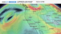
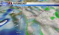
Chain restrictions are up for many of our passes Thursday morning, with whiteout conditions and closures likely later today. The heaviest snow will fall in the mountains between 9am and 8pm Friday, with snow showers tapering off Saturday afternoon. In the meantime, chain restrictions are posted for Interstate 80 west of Truckee, Mt. Rose Highway.

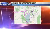
A Winter Storm Warning for the Sierra goes through at least Saturday morning, with most of the snow showers wrapping up by 3pm. Whiteouts and road closures are very possible today above 6,000 feet, including all our mountain passes.

In the valley, we’ll see light rain/snow throughout the day with a switchover to light snow by sunset. Cold front moves through Reno by 6pm, and there is a ton of cold air along with it. In advance of the front winds will be strong too with gusts around 40 miles per hour in Reno, and over 80 miles per hour for our high ridge tops. Gusts have already reached above 60 miles per hour in the mountains and will likely get even higher as the front gets closer Friday afternoon.

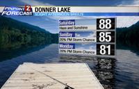
Snow totals will range from 12-30 inches above 7,000’, 7-12” at lake level, up to four inches in Carson City, and less than two inches in Reno. With a more westerly location of the low, there will be a lot of shadowing to work with, making a white Christmas a little bit less likely, but still possible. Temperatures will only be in the mid 30's Saturday afternoon, with some melting in the area.
Have a Merry Christmas.