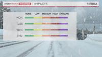
It’s the end of March or the beginning of April, and another winter storm is moving through the region early this week. Rain, snow, and wind will all play a role this week, with the snow being heavy at times in the Sierra.
A Winter Storm Warning is up for the Tahoe Basin through 11 p.m. Tuesday, and a Winter Weather Advisory is up for the Truckee Meadows above 5500' through 11 p.m. Monday.
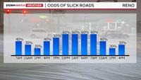
Mountain passes will be treacherous through Tuesday, with the worst of the storm on Monday. Visibility will be low, and roads will be slick as a result.
Snowfall rates will be around 1-2 inches per hour in the Sierra, making it very hard to see.
There are two parts to this storm.
There is the plume of moisture or weak atmospheric river, and there is the upper-level low. A plume of moisture to our south will combine with a cold front to bring frequent showers to the area on Monday. Then an upper-level low will move through on Tuesday, bringing more showers to the area.
The showers on Tuesday will be slightly less frequent and intense. Thunder and lightning are possible too. Thundersnow can produce a quick burst of intense snow when it develops.
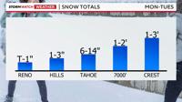
Snow totals will range from up to an inch in the valley below 5000’ to three feet at the crest of the Sierra.

The snow will have a lot of water content with it too. More snow will accumulate in our yards than on the pavement, but some slick spots are possible in the valley Monday evening as colder air moves in behind the front.
Watch out for some icy spots late Monday as well, especially on bridges and overpasses.
Thanks to a higher sun angle, valley roads will be wet during the day. Some snow could mix in from time to time though, mainly in the foothills, where 1-3 inches of snow is possible.
Virginia City will see a little more than that. Between 6 and 14 inches of snow will fall around Lake Tahoe.

Wind speeds will be strong in the high Sierra today and tomorrow, gusting over 70 mph in the high Sierra. 100 mph wind gusts are possible at the crest.
Strong winds will blow around the snow and help to lower visibility. Wind gusts in the valley will be around 40mph on Monday and 35mph on Tuesday.
The wind will also make it feel quite cold. Highs on Monday will be in the 40s for the valley.

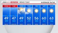
Quiet weather returns on Wednesday, with a gradual warming trend through the weekend. Spring-like weather and 60-degree temperatures return this coming Saturday.