The Washoe Zephyr is a type of wind that our area experiences on a regular basis. The wind is primarily felt in the summer season, when temperatures vary the most between the Sierra, Reno, and the Basin. Wind is related to pressure, density, and temperature differences. The Washoe Zephyr typically happens during the late afternoon and evening hours in the valley east of the Sierra. Wind gusts typically range from 20 to 30 miles per hour. The spring is usually the windiest season in our area. Washoe Zephyrs can be enhanced if there is a low moving through. Red Flag Warnings are issued when there is strong winds and low relative humidity for a decent amount of time. Even if a Red Flag is not issued, we always need to be fire aware in our area. This is especially true in the afternoon when the Washoe Zephyr kicks in. The difference is that a Red Flag Warning day has wind speeds staying strong for a long period of time, whereas the Washoe Zephyr is not an extended, long lasting event.


It forms from a process that involves pressure and temperature differences. First thing to note is that wind direction is described from where it is coming from. For example, if the wind barb is pointing west to east, with the wind coming from the west, it would be a west wind.


On a hot summer day the sun heats the earth and causes the air to rise. The warm parcels of air escape into the air, and lower the pressure at the surface. The warm parcels of air, now has nowhere to go so they get dispersed and move west. It then sinks near the Sierra. This added air and sinking motion creates high pressure. Wind flows from high to low pressure. You then get a west wind.

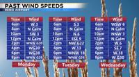
It has been a very typical summer week with temperatures around 90 degrees and late afternoon winds. Monday they were a little stronger than normal because we also had a low passing by to the north. The flow around a low moves counterclockwise. With the center up to our north the flow was already coming out of the west to begin with. Combine the already west wind with temperature differences the Washoe Zephyr was enhanced.


The forecast appears to stay about the same the next few days. Wind gusts will range from 20-30 miles per hour in the late afternoon and evening hours. Temperatures will be in the lower to mid 90’s. Have a great weekend and stay fire aware.