

Most storms come with cooler temperatures, but springtime and summertime storms are fueled by the heat of the day.
An area of low pressure will move through this weekend and will give us a mixed bag of weather, feeling like spring on one hand and winter on the other.
The snow level will be high, staying above 7500’ through Monday. It will be cold enough for snow along Mt. Rose Highway Monday morning, but it will be warm enough for just rain at Donner along I-80.

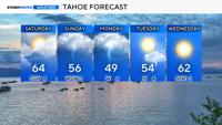
While it will be wet this weekend, it will not be cold. Highs on Saturday will be in the mid 70’s, and they will be in the lower 70’s on Sunday.
This is despite some high-level cloudiness. The clouds will keep instability values from soaring, but there won’t be enough cloud cover to avoid it entirely.
More instability equals a better chance for thunder and lightning, and can lead to taller storm clouds.

Due to the cloud cover, I don’t think all of the rain will be in the form of thunder and lightning, but it can’t be ruled out either.
The track of the low will also influence the location where storms develop as well.
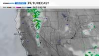
By Saturday afternoon, there will be a pathway for the storms to follow with a ridge to our east and a low to our west.
The low will be tiled somewhat, allowing for the storms to pop from Douglas County, the Pine Nut Range, and up through Pyramid Lake.

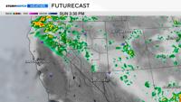
By Sunday, the low will be close enough for the showers to be numerous to widespread.
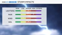
Rain will be heavy at times, and ice pellets can’t be ruled out either. The flash flooding risk is low, but ponding on roadways can’t be ruled out.
Showers will start in the Sierra by early Sunday afternoon and then expand eastward as the day goes on.
Whereas on Saturday, the storms will encompass a narrow band of showers and storms from Reno and Highway 95 northward.

Monday will be unsettled as well with a mix of rain, thunder, and high elevation snow.
The snow level will stay above 7,500’ or above Donner through early next week.
Highs on Monday will only be in the lower 60’s, but the rain and wind will make it feel even colder.
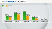
The threat of lightning goes down on Monday, but is not zero.

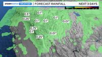
Rain totals will vary on Saturday, with many of us receiving light amounts but others receiving around a tenth of an inch.
Localized areas could see a quarter.
The rain on Sunday will range between .10 and .50 inches, depending on the strength of the thunderstorm. The rain will be moderate in nature, but there will be pockets of heavy rain and downpours.