

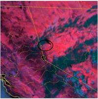
Technology can be great, especially when it comes to fire detection and keeping people safe. Satellites are better now, too, detecting hot spots and smoke plumes. While the smoke plume from the Bug Fire is hard to see on the standard infrared satellite, the GOES West Fire Temperature Composite satellite helps meteorologists pinpoint where the most significant fires are burning. The scale goes up to red, which indicates the hottest temperatures. The Bug and Fred Mountain Fires are being detected on the temperature satellite as little blinking squares. If you look closely, you can see red/pinkish squares between Pyramid Lake and the California state line.

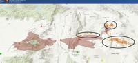
The fire maps on the Airnow.gov website also show fire detections as little brown dots. According to their map, fire is being detected east of the Bug Fire perimeter, south of Hungry Mountain, and through the western side of the Reno-Sparks Indian Colony. According to their website, fire/heat is also being detected on the north side of the Fred Mountain Fire, as well as along the northern border of the Bug Fire.
This is a tool that can help people see where the fire is potentially the most active and hottest, but it still needs to be verified out in the field. Similar to radar showing a severe thunderstorm or snow, while the radar might be showing something, spotters out in the field give us more confidence that this is happening. What this does show is the west-to-east movement of the fires. An updated perimeter map will be more official than the brown dots.