

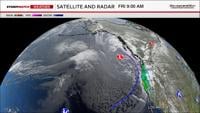
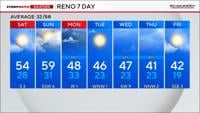
A strong storm is moving through the region Friday afternoon through early Saturday morning, with another storm moving through late Sunday into Monday and then again Wednesday and Thursday. Colder air is moving in and setting the stage for more winter like weather to move in next week.
It will be chilly this weekend and downright cold next week. Snowfall rates could reach 1-2 inches per hour through early Friday night. Rain totals in the valley will range between .05-.30” by Saturday morning, but localized areas could see closer to a half inch. Mainly for the foothills and south of I-80.

A strong area of high pressure was in place throughout much of this week, blocking storms from moving in here and keeping the jet pointed towards the Pacific Northwest. Now the ridge is well to our east allowing for storms to move in here. The air pattern is amplified with ridges and troughs instead of straight across. The cold air is here to stay with even colder air moving in next week. The jet stream acts like a jump rope, where if you pull on it you get hills and valleys. Large troughs keeps us active and cold this time of year.

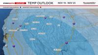
We have a series of storms moving in, not just one. The extended forecast is trending cooler than average. Reno usually sees it’s first measurable snow around Thanksgiving. Models have been showing another storm on Wednesday for a while, but we are still several days out. With highs in the 40’s and lows below freezing, it makes sense that any storm that does move through next week does have the potential to produce snow down to the valley floor. Especially at night. Cold, fluffy snow piles up easier than heavy wet snow like we are seeing Friday afternoon. How long the storm next week hangs around will greatly impact snow totals.