

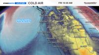
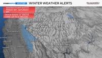
Our snow season is here and another winter storm is in the forecast beginning on Friday and going through early next week. A Winter Storm Watch is up for the Tahoe Basin from Friday morning through Saturday morning, and for Mono County from Friday afternoon through Saturday morning. This is only round one, with a second round moving through late Sunday into Monday. The second round will be colder and weaker. Snow totals will exceed several inches of snow above 7,000’ with a foot of snow likely in spots.

The valley will get a mixture of both rain and wind on Friday, as well as late Sunday into Monday. Down sloping winds can’t be ruled out either. Don’t be surprised if you see some Sierra Wave Clouds on Thursday, which can be indictive of turbulence and that a storm is coming. Wind gusts will exceed 40 mph in the valley on Friday as the low gets closer. As wind speeds relax, it will rain in the valley late Friday into early Saturday morning.

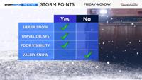
We’re still nailing down the specifics, exact timing, and totals, but the first round will pack the punch but will also be a fast mover. There will be a decent moisture plume to tap into with cold air moving in as well. Our mountain passes will be slow going with slick roads late Friday through Saturday morning, with improvement during the day. Not perfect though, due to uplift from the mountains. However, it won’t be as bad as Friday night. Conditions deteriorate late Sunday into Monday once again.

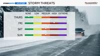
Snow levels will start out high, above 7,000’ and Donner Pass, before dropping to 6,000’ Friday night. They will bounce around a little bit on Saturday, before dropping again Saturday night into Sunday. Another round moves in late Sunday into Monday. The second round will drop the snow level to the foothills, but snow amounts will be limited.

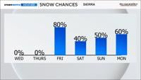
After lots of flip flopping, models are starting to show some agreement, especially with the first round. Some models keep the Sierra dry on Saturday, and others keeps snow showers lingering around. Without a direct west wind I don’t think the snow showers on Saturday will be as bad as Friday night, but they can’t be ruled out either. The models are in good agreement of a trough splitting in the Pacific, allowing for a low to move in behind it. Ensembles vary quite a bit on snow and rain totals, but are in agreement of the first round arriving on Friday and the second round moving in towards the end of the weekend into early next week. The current location of the trough and low matches with the model output, which gives me more confidence about the storm moving in on Friday.