Lake effect snow is a weather phenomenon that not only develops around the Great Lakes but can also develop off of Lake Tahoe and Pyramid Lake. Tuesday night brought heavy snow to parts of the Truckee Meadows, while other parts stayed mostly dry. Lake effect can be hard to forecast and usually very localized. This makes it difficult for models to pick up, and can catch people off guard. One part of town might be fine, but a small fraction of town is buried in snow. West Reno and the North Valleys usually sees more snow than Sparks, but this time around the northeast side of town got more than the west. It’s also rare for the Reno Airport to get more snow than the NWS office.
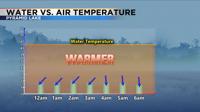
Lake effect snow requires cold air moving over a warmer body of water. The rule of thumb is for the water temperature to be at least 23 degrees colder than the lake. Late fall early winter is the most common time for lake effect to form, because the lake water is still a little warmer at this point. The storm that moved through Tuesday night, developed a little late in the season. With the mild January and February we’ve had, this is not totally surprising. A favorable wind direction that allows the air to flow overtop of the water is also necessary for lake effect to form. Different wind directions will lead to different snow potentials. Pyramid Lake encompasses more water from north to south than west to east, which means a north wind usually leads to more snow than a wind that is coming straight out of the east. A northeast wind is also better than an east wind.
As the cooler air moves over the warmer water, the air above warms, the air then rises and gathers moisture from the lake. The air eventually cools, condenses, and forms a cloud. The wind then carries the cloud downstream and when the cloud can’t hold the precipitation anymore it snows.

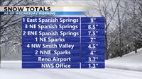
Snow totals ranged from a couple inches to nearly a foot downstream of Pyramid Lake. Spanish Springs and Palomino Valley got the most snow Tuesday night, with many people picking up several inches by morning. The National Weather Service got just over an inch and the Reno airport got a few inches as well. Carson City saw a little bit of lake effect from Tahoe earlier Tuesday afternoon. While most of the snow has melted off of our roadways, watch out for a few icy patches mainly in shady areas, as well as bridges and overpasses.