

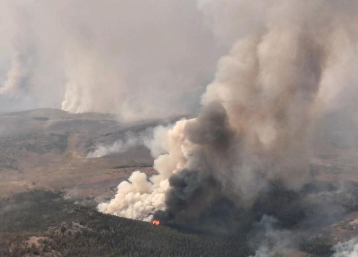
(Photos courtesy Forest Service)
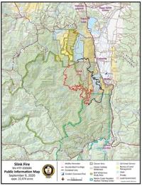
The Forest Service says the lightning-sparked Slink Fire is now 26,752 acres and is 84% contained.
It's two miles west of Coleville, California after sparking Saturday, August 29 in Slinkard Valley and is expected to be fully contained on Saturday, September 26th.
On Monday, crews held containment lines and did suppression where necessary. Smoke will again be impeding fire growth on Tuesday - crews will be watching for spotting and backing to keep the lines secured in areas where the fire could become active by wind.
The Forest Service says fires to the south are still very active.
The Humboldt-Toiyabe National Forest has temporarily closed all lands, including backcountry and wilderness areas, located in California on the Carson and Bridgeport Ranger Districts as of 8 a.m. on Thursday, Sept. 10. All campgrounds (developed and dispersed), day-use areas, trailheads, trails, and roads are closed to the public. No recreational activities will be allowed, including camping, hiking, hunting, fishing, or operating off-highway vehicles, etc.
The Forest Service says the Little Antelope Pack Station on Mill Creek Road was evacuated as a precaution.
The Forest Service says the following areas of National Forest System land are closed:
- From the Forest boundary west of Highway 395 from East Lane Road in Walker, California to Monitor Pass Road on Highway 89
- South of Highway 89 (Monitor Pass) to the northern edge of Summit Meadows Rd (Rd #32059)
- Summit Meadows Road to the Carson Iceberg Wilderness Trails including: East Carson River (#21011), Poison Flat (#21018), and Silver King (#21017)
- From the Forest boundary west of Highway 395 from Eastside Lane in Walker, California to Monitor Pass Road on Highway 89.
- South of Highway 89 (Monitor Pass) to the Highway 4 to Ebbetts Pass.
- East of the Pacific Crest Trail at Ebbetts Pass to Highway 108.
- North of Highway 108 to the Forest Service Boundary eastbound towards Highway 395.
For updates on the fire, click here.