The National Weather Service in Reno has issued a

* Severe Thunderstorm Warning for...
El Dorado County in northern California...
Placer County in central California...
Southern Washoe County in western Nevada...
Douglas County in western Nevada...
Western Carson City in western Nevada...

* Until 800 PM PDT.

* At 716 PM PDT, a severe thunderstorm was located near Tahoe City,
and is nearly stationary.

HAZARD...Quarter size hail.

SOURCE...Radar indicated.

IMPACT...Damage to vehicles is expected.

* Locations impacted include...
Carson City, Kings Beach, Tahoe City, Olympic Valley, Incline
Village, Spooner Summit, Incline Village-Crystal Bay, Glenbrook,
Crystal Bay, Carnelian Bay, Sugar Pine Point S, Homewood, William
Kent Campground, Dollar Point, Tahoe State Rec Area Campground,
Tahoe Vista, Silver Creek Campground, Meeks Bay Campground, and
Sunnyside-Tahoe City.

PRECAUTIONARY/PREPAREDNESS ACTIONS...

For your protection move to an interior room on the lowest floor of a
building.

If on or near lake Tahoe, get away from the water and move indoors
or inside a vehicle. Remember, lightning can strike out to 15 miles
from the parent thunderstorm. If you can hear thunder, you are close
enough to be struck by lightning. Move to safe shelter now!  Do not
be caught on the water in a thunderstorm.

&&


HAIL THREAT...RADAR INDICATED;
MAX HAIL SIZE...1.00 IN;
WIND THREAT...RADAR INDICATED;
MAX WIND GUST...<50 MPH
...RED FLAG WARNING REMAINS IN EFFECT UNTIL 10 PM PDT THIS
EVENING FOR THUNDERSTORMS AND STRONG OUTFLOW WINDS FOR THE SIERRA
FRONT...
...RED FLAG WARNING IN EFFECT FROM NOON TO 9 PM PDT FRIDAY FOR
THUNDERSTORMS AND STRONG OUTFLOW WINDS FOR THE SIERRA FRONT...
The National Weather Service in Reno has issued a Red Flag
Warning for thunderstorms and strong outflow winds, which is in
effect from noon to 9 PM PDT Friday.
* CHANGES...A new Red Flag Warning has been issued in the Sierra
Front for Friday afternoon when additional thunderstorms renew
a risk of dry lightning and strong outflow winds.
* Affected Area...Fire Weather Zone 420 Northern Sierra Front
including Carson City, Douglas, Storey, Southern Washoe,
Western Lyon, and Far Southern Lassen Counties, Fire Weather
Zone 421 Southern Sierra Front including Alpine, Northern
Mono, Southern Lyon, and Western Mineral Counties.
* Thunderstorms...Thunderstorm coverage and dry lightning
potential will be isolated through this evening, becoming more
widespread Friday afternoon.
* Outflow Winds...Gusty and erratic thunderstorm outflow winds,
even well away from rain cores. Gusts to around 50 mph possible
today and Friday afternoon.
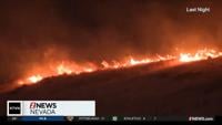
* Impacts...Lightning can create new fire starts and may combine
with strong outflow winds to cause a fire to rapidly grow in
size and intensity before first responders can contain them.
PRECAUTIONARY/PREPAREDNESS ACTIONS...
Avoid outdoor activities that can cause a spark near dry
vegetation, such as yard work, target shooting, or campfires.
Follow local fire restrictions. Check weather.gov/reno for
updates and livingwithfire.info for preparedness tips.
&&
...RED FLAG WARNING REMAINS IN EFFECT UNTIL 10 PM PDT THIS
EVENING FOR THUNDERSTORMS AND STRONG OUTFLOW WINDS FOR THE SIERRA
FRONT...

...RED FLAG WARNING IN EFFECT FROM NOON TO 9 PM PDT FRIDAY FOR
THUNDERSTORMS AND STRONG OUTFLOW WINDS FOR THE SIERRA FRONT...

The National Weather Service in Reno has issued a Red Flag
Warning for thunderstorms and strong outflow winds, which is in
effect from noon to 9 PM PDT Friday.

* CHANGES...A new Red Flag Warning has been issued in the Sierra
Front for Friday afternoon when additional thunderstorms renew
a risk of dry lightning and strong outflow winds.

* Affected Area...Fire Weather Zone 420 Northern Sierra Front
including Carson City, Douglas, Storey, Southern Washoe,
Western Lyon, and Far Southern Lassen Counties, Fire Weather
Zone 421 Southern Sierra Front including Alpine, Northern
Mono, Southern Lyon, and Western Mineral Counties.

* Thunderstorms...Thunderstorm coverage and dry lightning
potential will be isolated through this evening, becoming more
widespread Friday afternoon.

* Outflow Winds...Gusty and erratic thunderstorm outflow winds,
even well away from rain cores. Gusts to around 50 mph possible
today and Friday afternoon.

* Impacts...Lightning can create new fire starts and may combine
with strong outflow winds to cause a fire to rapidly grow in
size and intensity before first responders can contain them.

PRECAUTIONARY/PREPAREDNESS ACTIONS...

Avoid outdoor activities that can cause a spark near dry
vegetation, such as yard work, target shooting, or campfires.
Follow local fire restrictions. Check weather.gov/reno for
updates and livingwithfire.info for preparedness tips.

&&