

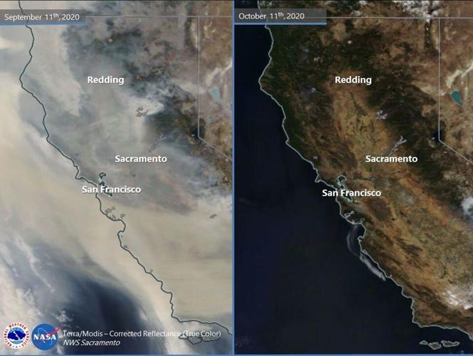
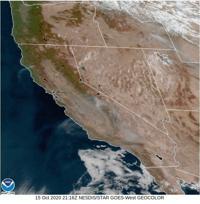
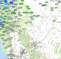
It’s been a while since we’ve gotten a good soaking of rain in Reno, but the sun is better than smoky skies. The second half of August through the month of September was very smoky along the west coast. Even parts of western Oregon were dealing with wild fires a month ago. While we are not completely out of the woods, conditions are improving. You can tell by looking at satellite images. The satellite image from September 11th shows an enormous amount of smoke up through California, Nevada, and Oregon. At the time we were mainly impacted by the North Complex Fire and Creek Fire. As of Thursday afternoon (October 15th), the Creek Fire is still producing smoke and is 55 percent contained. The North Complex Fire is 94 percent contained. The Red Salmon Complex Fire is 62 percent contained and is 142,387 acres in size. You can see some of its smoke on satellite images too. Overall, it’s a vast improvement from a couple months ago. With a change in wind speed and direction a little more smoke could move north from the Creek Fire, but it will mainly stay south of Carson City. The air quality forecast is good both Friday and Saturday in Reno. Slightly worse for areas farther south.

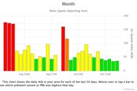
The last time Reno’s average air quality was in the unhealthy range was September 30th. It’s been great to breathe in clean air for the past two weeks. With that being said, the air quality is still around the unhealthy range for places near the Creek Fire.

August 24th was the last time Reno saw more than a trace of rain at the airport. Northern California got some rain last weekend. Totals ranged from about an inch in far northwestern California to less than a few hundredths to the east.

Wind speeds will be fairly light this weekend in Reno but there is A Red Flag Warning posted for north central California through 11am Friday because of strong winds and dry air. Wind speeds will range from 15-25 miles per hour with gusts in the 40’s. Winds will be light in the Truckee Meadows with the direction coming out of the east. An east wind is good for us, but amplifies as it goes over the hill. Highs this weekend will be in lower 80’s with lows in the 40’s. No rain is in sight anytime soon. If you want cooler weather, South Dakota is expecting highs in the 40’s next week. Our winter outlook shows warmer than normal temperatures and below average precipitation.