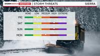
Cold air combines with plentiful moisture to create a good snowstorm in the Sierra this weekend. This will be a moderate storm with feet of snow falling in the high Sierra. Thanks to the direction of the flow, Reno will see some shadowing and more wind than rain. Wind gusts will top 30mph in the valley and near 100mph at the crest. Wind speeds will be their strongest on Saturday.

The Winter Storm Warning for the Tahoe Basin and parts of northeast California goes from 12am Saturday through 10am Monday. Not only will the snow be heavy at times, but visibility will be poor and winds will be strong.

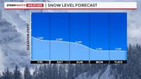
Snow levels will bounce around on Saturday, but will fall to roughly 5,500’ Monday. It will be cooler at night, when the foothills could see some light snow Saturday, Sunday, and Monday morning. Shadowing will limit the amount though.
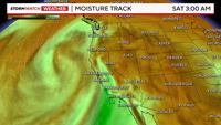
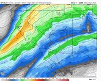
A southerly oriented flow pattern, typically increases shadowing in the Reno area, but if the air mass is convective, spillover is easier. The amount of moisture plays a role as well. This will be a high end moderate atmospheric river, with some colder air to work with. The moisture is coming up from the south-southwest, and will slowly move southeast this weekend.


There is still a flood risk in Northeast California, with a Flood Watch up for that region of California this weekend. It is primarily for the Susan and Feather rivers, going from 10am Saturday through 4pm Monday. The timing of when the cold side of the storm arrives is crucial in how much snow will fall at lake level and the foothills.
Snow is likely at Donner throughout the duration of the storm. The high Sierra above 7,000' will see 1-3 feet of snow, with 6-10 inches possible at lake level. Mono County above 8,000' will see up to four feet of snow.

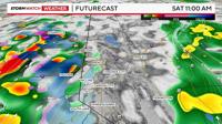
Thunderstorms are possible in northern California through Sunday. Which means this storm will have a convective side to it. Since this storm will be somewhat convective, the snow will be showery on Saturday, with small breaks in between heavy bursts of snow. The snow won’t be steady on Saturday, but will be more persistent by late Saturday night into Sunday morning as another wave moves into the Sierra.

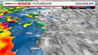
The heaviest snow will fall at this time as well. This is when the Jetstream, or upper level winds starts to intensify once again, giving the air a boost to rise and produce snow.

The Jetstream will stay tilted in a southwesterly direction for a while late Saturday, making the snow more steady. This will be the case early Saturday as well.

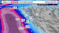
Snow totals will range from 6-10 inches at lake level to up to four feet at the crest of Mammoth Mountain. For Tahoe, elevations above 7,000' could see up to three feet of snow.
The atmospheric river weakens some by Monday, so while the snow level will drop Monday morning, there won’t be as much moisture. This means that the Reno area has a slight chance of seeing a slick commute Monday morning. If any snow falls, it would be light, but even a dusting can cause a lot of problems. So stay tuned.
You can find more graphics on our NevadaWX 2Go page.