Pack chains if you plan on traveling this weekend in the Sierra. Snow is likely and a Winter Storm Warning is up for the Tahoe Basin as a result.
The snow will be slushy and will accumulate on grassy areas more than the road, however, it will stick to the pavement at times, especially at night. Snowfall rates could reach 2-3 inches per hour late Saturday, which is heavy enough to stick to the pavement.

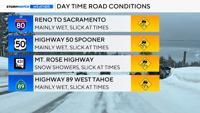
Roads will be mainly wet during the day, but snow could still accumulate on the pavement at times. Visibility will be poor as well.
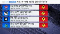
Roads will be worse at night as temperatures fall and the snow is able to accumulate at a much quicker rate. Visibility will be poor throughout the storm due to blowing snow.

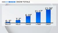
Snow totals will range from six to ten inches at lake level, to over a foot in the High Sierra.
Even the valley could see some light snow early Sunday morning.
The foothills of Reno could see up to two inches, including Virginia City, the North Valleys, and Galena.
Carson City has a slightly better chance at seeing accumulating snow than Reno. Any snow that does fall will mainly accumulate on grassy areas and melt very quickly. No accumulations are expected closer to downtown or the airport.
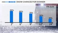
The odds of seeing at least a few inches of snow at Donner is 90% and it’s a 50% chance of at least seeing a foot.
The snow will initially come in bursts or showers, before turning more widespread late Saturday and Sunday. Thunder and lightning can’t be ruled out either. Snowfall rates could reach 2-3 inches per hour with stronger snow bands late Saturday into Sunday - which is heavy enough to accumulate. Visibility will be poor as well.

Snow ratios will be low, due to the lack of really cold air. The higher the snow ratio, the lighter and fluffier it will be. Fluffy snow piles up easier than moist snow.
The snow will have a good amount of water within it, which is great for our soil moisture. In fact, the Sierra could see inches of water over the weekend, from either rain or melted snow.
Due to a higher sun angle, the snow will melt pretty quickly next week, so it won’t really make a difference with our snowpack.

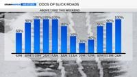
This graphic begins Friday evening and goes through the weekend. Roads will be worse at night than during the day. However, snow will still accumulate on roadways at times during the day as well. Saturday night into Sunday morning will be the most dangerous part of the storm.
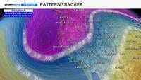
Confidence is fairly high as a low coming down from the north over the ocean, typically gives the Sierra a good chance of snow.
The ocean provides the storm with moisture, and the location of the low coming from the north keeps the air mass cold.
Granted this time of year, it can be warmer up north as well. This time however, it will be cold enough for snow.

Pretty much all of the deterministic models are showing over a foot of snow this weekend in the Sierra.
The Euro model favors the southern Sierra though, while the GFS and NBM is pretty uniform throughout. The ensembles of the GFS are showing lesser amounts than the main GFS model. This tells me snow is likely, with at least several inches, and a foot is a pretty good bet as well. Two feet however, is less certain.

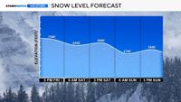
The snow level drops to 7,500’ by Friday evening and stays between 6,500’ and 6,800’ on Saturday before dropping to the valley floor Sunday morning.
Showers are still possible on Sunday as a low travels east over Reno. Moisture will be less favorable by the second half of the weekend though. The snow will be the most intense Saturday night. None to minimal impacts are expected in Reno and Carson City.