Atmospheric rivers can provide the west coast with a lot of water during the winter season, and the first decent one of the season will move through this week. It will mainly affect northern California and the Pacific Northwest, but it will be close enough to Reno to feel some impacts down here as well.
Atmospheric rivers are channels of moisture that can stretch all the way out to the Hawaiian Islands. They are notorious for bringing strong winds, heavy rain, and snow along with them.
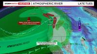
Models are showing a moderate to strong atmospheric river moving through Northern California late Tuesday through early Friday.

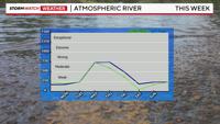
The atmospheric river will move into the Pacific Northwest by early Wednesday, with the center of it moving towards Redding, California. Without a dead-on west direction, there won’t be as much spillover in Reno to begin with, but there will be a lot of wind. It will be a windy week in the Truckee Meadows, with gusts exceeding 30mph at times.
Northern California could easily pick up at least an inch of rain by Friday, and Lassen National Park could see over two feet of snow between Tuesday and Thursday.

Reno’s best chance for rain will be late Friday into the weekend as the low itself moves southward. The low will provide some lift and the moisture plume will be close enough to fuel the storm. We are still too far out to get a solid handle on snow levels, totals, or exact wind speeds, but if you have travel plans the later half of this week I would think of a plan B just in case.
Flooding is not expected at this time, but creeks and streams will get higher.

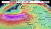
Atmospheric rivers are driven by the low level jet, while the 300mb jet is what creates more ridges and troughs higher up in the atmosphere. By the time the 300mb jet moves south, the low level jet and meat of the atmospheric river (moisture) will be further south. The low will still be able to tap into some of the moisture, but totals won’t be as high as northern California. Stay tuned for more updates.
The image below shows the 300mb jet moving south, allowing the air to rise in our area by Friday night.