
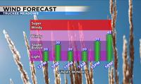
Not expecting much in the way of moisture over the next several days but the wind machine will be cranked on high Sunday afternoon and full blast Monday. High temperatures will still be in the upper 60’s and 70’s, but the wind will make it feel a little cooler especially once the sun goes down. A weak system will move through the region on Sunday allowing for some high level cloudiness as well as afternoon breezes. Wind gusts on Sunday will be of the garden variety, similar to the Washoe Zephyr that develops because of temperature differences throughout the region. Wind gusts will be much stronger Monday as the temperature gradient heightens. Now is the time to secure any loose items and perhaps bring them indoors.

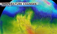
Temperatures won’t drop that much from Sunday to Monday, but the jet stream will be situated just to our north keeping warm air over Nevada and cooler air over Oregon and Idaho. Temperature is related to pressure, and the bigger the pressure difference within a short space the tighter the gradient and the stronger the wind speed. The cooler air to the north will buckle and move south late Monday dropping temperatures a few degrees on Tuesday. Wind speeds will be lighter by then too.

Wind speeds will be the strongest north of I80, because the jet stream will be situated just north of I80 as well. The jet stream is a river of air with strong winds. Wind speeds will range from 35 miles per hour Sunday in most locations to 45 miles per hour in wind prone areas. Wind prone areas could see gusts closer to 60mph on Monday. The strong winds will lead to blowing dust and hazardous boating conditions. Blowing dust is dangerous because it can lower visibility just like a snow storm. It can also come on suddenly. The dust will come from the various sink holes in the region. Central Nevada and places downwind of northeast California has the best chance to see blowing dust on Sunday and Monday.