...THUNDERSTORMS DEVELOPING ACROSS NORTHEAST CALIFORNIA AND PORTIONS
OF WESTERN NEVADA THROUGH 700 PM PDT...

At 504 PM PDT, thunderstorms are moving northward across western
Nevada. Additional thunderstorm development is likely through the
early evening.

HAZARD...Wind gusts up to 50 mph and half inch hail. Blowing dust
possible near desert sinks and playas.

SOURCE...Radar indicated.

IMPACT...Gusty winds could knock down tree limbs and blow around
unsecured objects. Minor hail damage to vegetation is
possible.

Locations impacted include...
Reno, Fallon, Lovelock, Herlong, Gerlach, Pyramid Lake, Lahontan
Reservoir, Doyle, Sparks, Fernley, Susanville, Dayton, Hawthorne,
Yerington, Wingfield Springs, Golden Valley, Virginia Peak,
Middlegate, Hidden Valley, and Standish.

PRECAUTIONARY/PREPAREDNESS ACTIONS...

If outdoors, consider seeking shelter inside a building.

&&


MAX HAIL SIZE...0.50 IN;
MAX WIND GUST...50 MPH
...FLASH FLOOD WARNING REMAINS IN EFFECT UNTIL 645 PM PDT THIS
EVENING FOR STOREY AND SOUTHERN WASHOE COUNTIES...
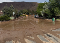
At 444 PM PDT, Local law enforcement reported flash flooding and
debris flows in the Hidden Valley area and along I-80 between Vista
Blvd and Lockwood. Between 1 and 1.5 inches of rain have fallen.
Flash flooding is already occurring.
HAZARD...Life threatening flash flooding. Thunderstorms producing
flash flooding.
SOURCE...Law enforcement reported.
IMPACT...Life threatening flash flooding of creeks and streams,
urban areas, highways, streets and underpasses.
Some locations that will experience flash flooding include...
Reno, Sparks, Lockwood, Hidden Valley, Spanish Springs and Mustang.
PRECAUTIONARY/PREPAREDNESS ACTIONS...
Turn around, don't drown when encountering flooded roads. Most flood
deaths occur in vehicles.
Be aware of your surroundings and do not drive on flooded roads.
&&
FLASH FLOOD...OBSERVED;
FLASH FLOOD DAMAGE THREAT...CONSIDERABLE
...FLOOD ADVISORY IN EFFECT UNTIL 730 PM PDT THIS EVENING...

* WHAT...Flooding caused by excessive rainfall is expected.

* WHERE...A portion of western Nevada, including the following
county, Washoe.

* WHEN...Until 730 PM PDT.

* IMPACTS...Minor flooding in low-lying and poor drainage areas.

* ADDITIONAL DETAILS...
- At 434 PM PDT, Doppler radar indicated heavy rain due to
thunderstorms. Minor flooding is ongoing or expected to begin
shortly in the advisory area. Between 0.5 and 1 inch of rain
has fallen.
- Some locations that will experience flooding include...
Sparks, Spanish Springs, Wingfield Springs, Spanish Springs
Airport and Sun Valley.
- http://www.weather.gov/safety/flood

PRECAUTIONARY/PREPAREDNESS ACTIONS...

Turn around, don't drown when encountering flooded roads. Most flood
deaths occur in vehicles.

&&
...RED FLAG WARNING REMAINS IN EFFECT FROM NOON TODAY TO 9 PM PDT
THIS EVENING FOR THUNDERSTORMS AND STRONG OUTFLOW WINDS FOR THE
SIERRA FRONT...

* CHANGES...No changes.

* Affected Area...Fire Weather Zone 420 Northern Sierra Front
including Carson City, Douglas, Storey, Southern Washoe,
Western Lyon, and Far Southern Lassen Counties, Fire Weather
Zone 421 Southern Sierra Front including Alpine, Northern
Mono, Southern Lyon, and Western Mineral Counties.

* Thunderstorms...Thunderstorm coverage and dry lightning
potential will become more widespread by the afternoon into the
evening.

* Outflow Winds...Gusty and erratic thunderstorm outflow winds,
even well away from rain cores. Gusts to around 50 mph
possible today and Friday afternoon.

* Impacts...Lightning can create new fire starts and may combine
with strong outflow winds to cause a fire to rapidly grow in
size and intensity before first responders can contain them.

PRECAUTIONARY/PREPAREDNESS ACTIONS...

Avoid outdoor activities that can cause a spark near dry
vegetation, such as yard work, target shooting, or campfires.
Follow local fire restrictions. Check weather.gov/reno for
updates and livingwithfire.info for preparedness tips.

&&